As we head towards Christmas there is, as always, a great deal of media and public speculation about what weather we might have in store for the festive season as well as the rest of winter.
Starting with Christmas and the all-important question of whether it will be a white or not. Wintry showers are expected in the north which could technically make it a white Christmas, as we only need to see a single snowflake falling, but any lying snow will probably be confined to the mountains of Scotland. Elsewhere, showers are likely to fall mostly as rain, and so it’s unlikely that we will see widespread or settling snow this year. So although technically it might be a white Christmas in a few places, don’t get your hopes up for a picture-perfect white landscape. Looking towards the New Year, the weather looks to remain unsettled with low pressure bringing periods of breezy and wet weather for many.
To answer questions about the rest of winter, we need to look beyond the UK. The worlds’ weather is interconnected, and there are large scale global drivers which we know have influences on UK weather at this time of year – so what are these doing at the moment?
A strong El Niño, the naturally occurring warming of the Pacific Ocean, is underway. This increases the likelihood that the second half of winter and early spring will be colder and drier than the first half.
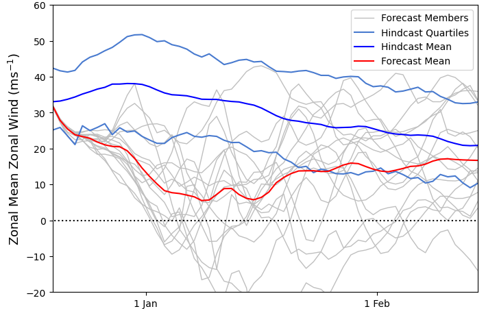
The Stratospheric Polar Vortex is also weakening, which increases the chances of a Sudden Stratospheric Warming (SSW). A SSW often makes the jet stream (5 to 7 miles above the Earth) meander more, which can lead to the development of a large area of high pressure over northern Europe at the Earth’s surface. This can ‘block’ the Atlantic low pressure systems, which often bring mild, wet and windy weather, from crossing the UK. Therefore, increasing the chance of cold, dry weather here and mild, wet and windy conditions for southern Europe. However, the impacts of an SSW on UK weather can also be benign, it does not always equate to cold weather, for example, in 2019, there was an SSW but little impact on the weather for the UK and NW Europe.
Stratospheric Polar Vortex strength 19 December 2023

Professor Adam Scaife, Head of Long-Range Forecasting at the Met Office, said: “There is an increased chance of an SSW occurring later this winter. Although any impacts will become clearer nearer the time, any effect on UK weather is most likely to occur in January and February.”
Another factor also influencing the UK this winter is the Quasi-Biennial Oscillation (QBO), a regular variation of the winds that blow high above the equator. It is currently in an easterly phase which also increases the likelihood of an SSW. Meanwhile, the current pattern of sea surface temperatures in the North Atlantic Ocean is also conducive to a reduction in the chance of westerlies. These effects are on a background of warming UK winters, consistent with wider global warming trends.
The science of longer-range and seasonal outlooks is at the cutting edge of meteorology and the Met Office is one of the leaders in scientific research in the area. However, even with ‘perfect’ prediction systems and ‘perfect’ meteorological observations, the fundamental chaotic nature of the atmosphere will still limit the skill of these predictions. Although, the science does not allow for specific detail on the amount of rain or snow over the coming months or exactly when severe weather may occur, long-range forecasts can provide useful information on the likelihood of possible conditions averaged over the UK for the season as a whole.
You can check the long range forecast and daily weather forecast on our website. You can also follow us on Twitter and Facebook, as well as on our mobile app which is available for iPhone from the App store and for Android from the Google Play store. Our three-month outlooks are updated each month. Keep track of current weather warnings on the weather warning page.


