

A look back at Winter 2024/25 and February 2025's provisional weather and climate statistics.
Winter 2024/25 closed out on a bright and sunny note for most, although the same cannot be said for the majority of the season. Provisional Met Office statistics show that this winter saw below average rainfall, below average sunshine, and above average temperatures for the UK.
No significant meteorological records were broken, however the seasonal statistics mask two high-profile events, with Storm Darragh in December and Storm Éowyn in January both warranting Met Office Red National Severe Weather Warnings for their significant risk to life.
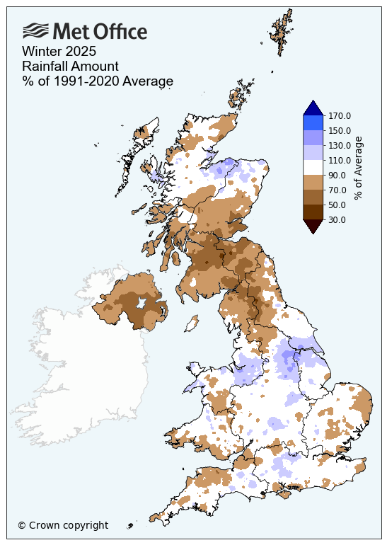
Below average rainfall, especially for Northern Ireland
As winter drew to a close, many places were still feeling rather soggy following a weekend of heavy rain, but after a wetter than average December and a drier than average January and February, winter concluded with 11% less rainfall than its long-term meteorological average. The southern half of the UK experienced the wettest conditions, with England and Wales both recording 94% of their average rainfall over the season. Northern Ireland though saw far less rainfall, with just 70% of their average.
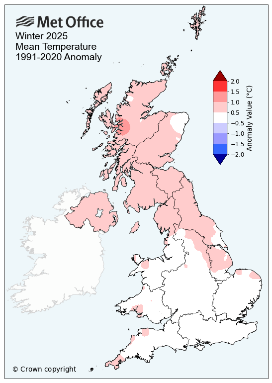
Above average temperatures, especially for Scotland and Northern Ireland
Winter started off on a warm note, with December 2024 the fifth warmest December on record for the UK. January however, brought below-average temperatures, with snow, widespread frosts and freezing fog. However, with above average temperatures in February, Winter 2024/25 has seen above average temperatures for the UK, with a mean temperature of 4.6 °C, which is just over half a degree above the long-term meteorological average. There has of course been much regional variation, with Wales and England seeing closer to average figures and Scotland and Northern Ireland being warmer than average.
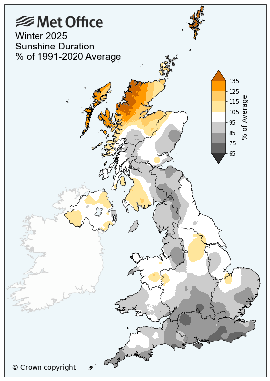
Lacking in sunshine, except for parts of Scotland and Northern Ireland
January 2025 was the fifth sunniest on record for the UK. But an incredibly dull December (seeing just over half its average sunshine) and a below average February, pulled winter’s figures down to 6% less sunshine than its long-term meteorological average. This wasn’t the story for everywhere though, with Northern Ireland and Scotland seeing the best of the sunshine, with 103% and 104% of their respective averages. Northern Scotland in particular enjoyed seeing 121% of its average sunshine across the winter.
Two named storms
Winter 2024/25 saw two named storms, which both warranted the Met Office issuing red National Severe Weather Warnings for their significant risk to life.
Storm Darragh, the fourth named storm of the 2024/25 storm season, brought very strong winds to western parts of England and Wales in early December. A red warning for wind was issued, with wind gusts of 96mph recorded at Berry Head in Devon and 93mph at Capel Curig in Wales. A number of deaths were reported over the weekend as Storm Darragh impacted the UK. Arriving just two weeks after Storm Bert led to widespread flooding, Storm Darragh also brought heavy rain and concern about further flooding in areas affected by Storm Bert.
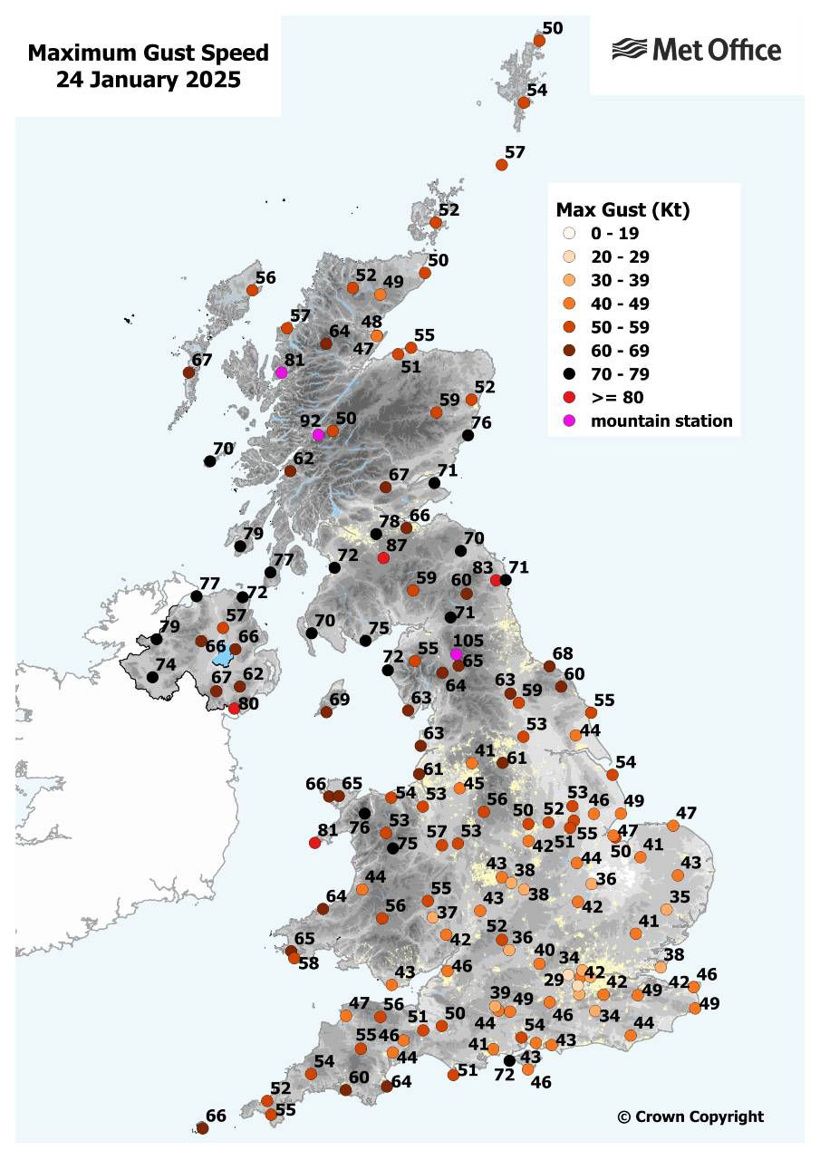
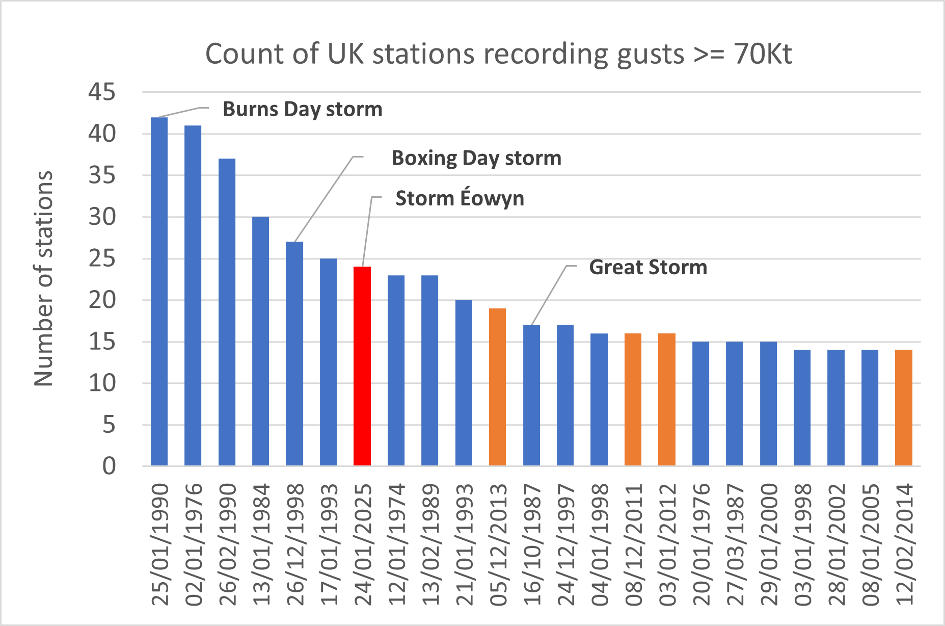
Storm Éowyn, the fifth storm of the 2024/25 season so far, hit the UK in late January. It was the UK’s most powerful windstorm in over a decade, bringing red warnings, severe impacts and, tragically, fatalities. Northern Ireland and Scotland’s Central Belt experienced the brunt of this storm with winds gusting widely at well over 80mph. The highest wind gust recorded in the UK was 100mph at Drumalbin in Lanarkshire and a weather station on Tiree, Inner Hebrides, recorded the UK’s lowest pressure reading since storm naming was introduced in autumn 2015.
The map below shows maximum gust speeds on 24 January 2025 from Storm Éowyn.
Met Office Scientist Emily Carlisle said: “This winter has seen a typical mix of UK winter weather conditions, with a mix of wet and windy, but also cold and calm conditions. This has resulted in a season where no significant climate records have been broken, but the statistics do mask two high-profile events, with Storm Darragh in December and Storm Éowyn in January both warranting red National Severe Weather Warnings for their significant risk to life.”
The chart below counts the number of stations in the UK by day with a maximum gust >= 70Kt (81mph) in observational records from the early 1970s.
|
Provisional Winter 2025 stats |
Mean temp (°C) |
Rainfall (mm/%) |
Sunshine (hours/ %) |
|||
|
Actual |
91/20 anom |
Actual |
91/20 anom |
Actual |
91/20 anom |
|
|
UK |
4.6 | 0.5 | 308.0 | 89 | 153.0 | 94 |
|
England |
5.0 | 0.4 | 227.4 | 94 | 164.8 | 90 |
|
Wales |
5.0 | 0.4 | 424.5 | 94 | 151.7 | 96 |
|
Scotland |
3.7 | 0.7 | 425.0 | 86 | 133.7 | 104 |
|
Northern Ireland |
5.4 | 0.7 | 230.7 | 70 | 152.4 | 103 |
February 2025
February 2025 ended on a sunny and bright note for most, but it may be remembered for its long-lived Scandinavian high, which stayed for a good while during the middle of the month bringing cold, cloudy, dull and dry conditions for many.
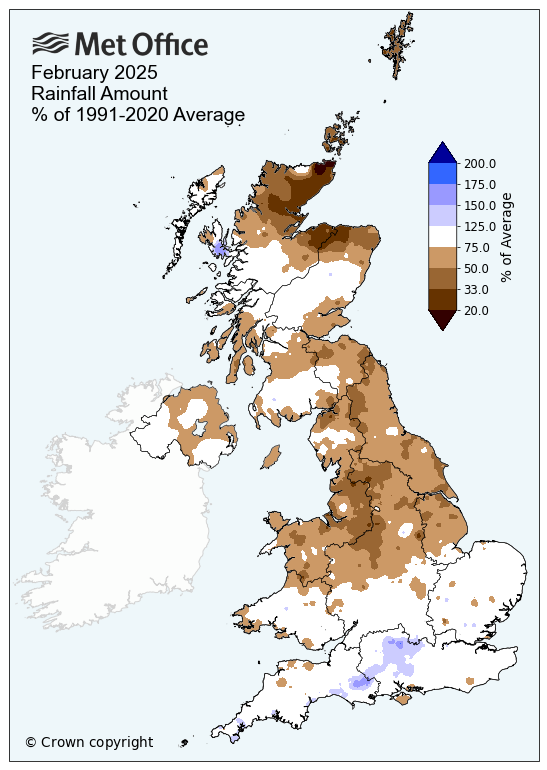
Very low rainfall – especially in the far north of Scotland
February started with very little rainfall, but this shifted mid-month as the weather became more unsettled thanks to a shift in the jet stream. Rainfall was still well below average, with the UK provisionally recording 72.7mm of rain, 76% of the long-term meteorological average.
The far north of Scotland recorded some very low rainfall, with Orkney seeing just 34% of its average, Sutherland 37% and Shetland 40%. These figures do not trouble any records, with only Caithness recording its 9th driest February since the series began in 1836.
Northern England was also particularly dry, seeing just over half (56%) of its average rainfall in contrast to southern England, which saw 95% of its February average.
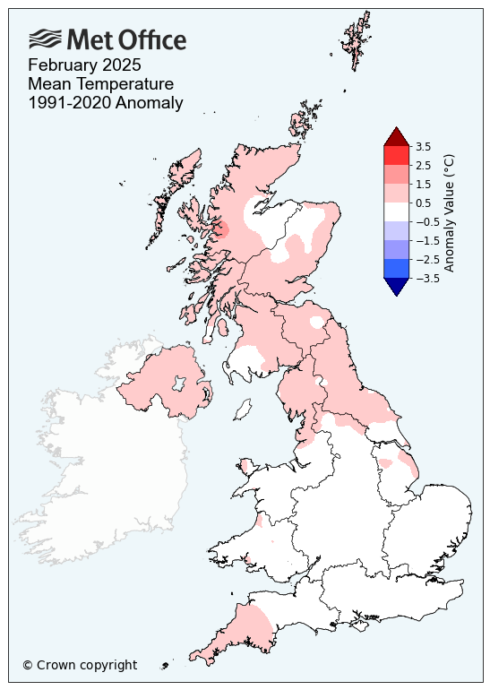
Below average temperatures – warmer in the north
Although temperatures for the UK in the first two weeks of February were below average, the shift mid-month to warmer conditions led to an overall mean temperature of 4.6°C, which is 0.5°C above the long-term average. The north of the UK saw generally warmer conditions, with Northern Ireland in particular provisionally seeing temperatures of 0.9°C above average. Scotland too enjoyed the warmth, with temperatures 0.7°C above average. Both the Western Isles and Shetland recorded their 10th highest maximum temperature since the series began in 1884.
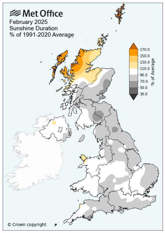
Below average sunshine – except in Scotland
Although it felt like a rather dull month for many, February did end on a sunnier note for most, which boosted the UK's average sunshine to 67 hours, 93% of its long-term meteorological average.
This average is pulled up by Scotland and Northern Ireland, which both enjoyed 104% and 99% of their February average of sunshine across the month. Scotland in particular saw much variation, with northern Scotland recording 137% of its average, compared to eastern Scotland at 80% and western Scotland at 90%.
|
Provisional February 2025 stats |
Mean temp (°C) |
Rainfall (mm/%) |
Sunshine (hours/ %) |
|||
|
Actual |
91/20 anom |
Actual |
91/20 anom |
Actual |
91/20 anom |
|
|
UK |
4.6 | 0.5 | 72.7 | 76 | 67.0 | 93 |
|
England |
5.0 | 0.4 | 52.2 | 79 | 67.5 | 87 |
|
Wales |
4.8 | 0.3 | 90.3 | 75 | 68.1 | 98 |
|
Scotland |
3.8 | 0.7 | 102.6 | 73 | 65.8 | 104 |
|
Northern Ireland |
5.6 | 0.9 | 71.2 | 78 | 66.4 | 99 |