

We take a look back on meteorological winter 2024/25, how the forecast developed and the impact it had.
While bright and sunny weather marked the end of meteorological winter (December, January, February) for many, the season had its fair share of impactful, and at times destructive, weather.
Although the provisional weather and climate statistics show a slightly drier, duller and warmer winter for the UK compared to the long-term average, these figures mask what has been a mixed season with periods of severe weather, two named storms, over 100 Met Office warnings and spells of wintry hazards such as snow and ice for some.
Long-term preparedness
The Met Office begins preparing for winter weather well in advance of the season. We provide briefings to government, stakeholders and industry outlining the most likely scenarios for the coming winter.
To assess the possible conditions, Met Office weather prediction models are run hundreds of times with expert meteorologists studying these model outcomes together with the global weather and climate systems to predict the most likely scenarios for the coming months.
With government and stakeholders briefed on the probabilities of dominant conditions for the season ahead, the focus shifts to the immediate forecast and, crucially, Met Office weather warnings.
Storms and warnings during the winter
Meteorological winter is one of the busiest seasons for weather warnings from the Met Office.
Shifts in the jet stream at this time of year can result in an increase in the frequency of Atlantic low pressure systems bringing wind and rain to the UK. Some of which bring extreme weather and develop into named storms.
Flooding is often one of the main impacts of this extreme weather. and while the Met Office is responsible for forecasting rainfall, we work in collaboration with the Environment Agency via the Flood Forecasting Centre, the Scottish Environment Protection Agency, Natural Resources Wales and Northern Ireland Direct to fully capture the risks of individual regions through the season. Local sensitivities of rivers and catchment areas to rainfall as well as tide times can often influencing the likelihood of flooding.
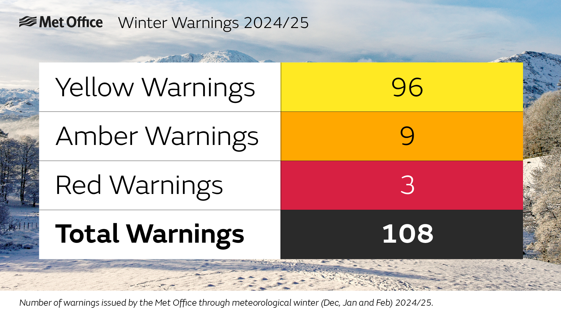
A total of 108 severe weather warnings were issued during meteorological winter 2024/25. As you’d expect, the majority of warnings fall into the yellow category, with 9 Amber Warnings and 3 Red Warnings.
The total number of warnings during the season (December, January and February) was slightly lower than the previous winter, which also had six named storms rather than the two this time around.
Storms Darragh and Eowyn both resulted in red warnings being issued by the Met Office, which indicate a high likelihood of danger to life.
The first warning for Storm Eowyn was issued on 20 January, before the system had even formed as a distinct feature ahead of its arrival on the 24th.
Met Office Director of Science Simon Vosper explained: “Storm Eowyn was an example of just how far forecasting models have come in recent decades. The transition to a wet and windy period of weather was signalled well in advance, and to have the confidence to issue warnings and name the system before it had even formed is a testament to the scientific progress made in the field of Numerical Weather Prediction.
“We issue warnings well in advance of severe weather allows communities to plan. We of course continue to refine and amend our forecast in the run-up to the event, ensuring, as far as possible, that people get access to the latest information they need to stay safe.”
Both Darragh and Eowyn brought significant impacts, with Eowyn being the UK’s most significant windstorm in over a decade.
Did warnings and storm names help raise awareness?
Warnings are issued to help people prepare for severe weather and to therefore minimise impacts. The same is true of why storms are named; often providing a key focus for public and media communication of severe weather events.
Post-event surveys suggest that warnings and storm names are highly effective, not just for public awareness, but also when it comes to taking action to minimise the impacts of severe weather.
For Storm Darragh (6th to 7th December 2024), which brought a peak gust of 96mph and significantly strong winds for parts of Wales and the southwest of England, 98% of those within Red National Severe Weather Warning areas were aware of the warning, and 91% of those took direct action to minimise impacts. Some actions noted include securing things around the house, staying in or even preparing for a power cut kit.
Storm Eowyn (24th January 2025), which also resulted in a Red Warning, had a 99% awareness rate for those within this area, with 95% of those taking action to protect themselves or their property. Gusts for Eowyn peaked at 100mph, as highlighted as a possibility within the warnings.
In addition, an Amber Warning for snow in the north of England from 4 January also had over 90% awareness, as well as over 90% of those taking action and finding the warning useful.
Reflecting on the season, Met Office Services Director Simon Brown said: “The mix of winter weather - snow, ice, fog, wind and rain means we have multi-hazards and associated impacts to manage during the winter season and alignment from Met office forecasting through to impacts and response is critical. I’m pleased we can demonstrate throughout this season, not just the impact our warnings and advice to the public have had, but also how our engagement has supported local first responders, government and partner agencies.
“I’m proud of the collective efforts across the Met Office to forecast and communicate the risks. I’m proud alongside the work with our partners we have been able to minimise the impacts and keep the country running which is important to stimulate economic growth. As always, there’s no time to rest, with spring often bringing the potential for further storms or impactful weather.”
Communicating the forecast
Over 400 weather briefings were delivered around the country through the season, with Met Office Civil Contingency Advisors helping to communicate the forecast to responders as needed.
The public access their forecast in a variety of ways, with the Met Office having a plethora of social media channels, as well as the website and app and appearing in the media, online and on TV and radio.
Through social media alone, over 240million impressions have been generated during winter across Met Office channels on X, Facebook, Instagram, TikTok, YouTube and LinkedIn. Peaks in activity, as expected, centre around Storm Darragh in early December, Amber Snow warnings in early January and Storm Eowyn later in January.
YouTube in particular proved to be popular, with long-form formats like Deep Dive, which explains the meteorology behind the medium and long-range forecasts, and 10-Day Trend, which explores the scenarios beyond the usual forecast period, regularly the most popular content.
Similar trends were noted on the usage of the Met Office website and app, with January (which included amber snow warnings and Storm Eowyn, seeing the highest number of Met Office page views in the season.