This year the UK saw records broken in almost every season, plenty of named storms, an abundance of weather warnings, and a rare night-sky phenomenon. Here’s a recap of 2024.
The UK’s highly variable climate means that every year is different. However, much like 2023, 2024 broke both temperature and rainfall records, with storms and snow also hitting the headlines and having real-life impact.
A warm welcome
Winter 2023/24 was in the top 10 warmest and wettest for the UK, with significantly fewer ground frosts than average. A mean average temperature of 5.29°C across the three months made it provisionally the fifth warmest winter on record.
The season also saw six named storms – Elin, Fergus, Gerritt, Henk, Isha, and Jocelyn – and it was just the second time the UK storm season has reached the letter J.
On January 2, Storm Henk brought damaging winds, with Exeter Airport in Devon recording a gust of 81 mph, the highest January wind speed recorded at that location.
Record breaking temperatures and rainfall for February
We experienced the warmest February on record for both England and Wales, with the average temperature in England reaching 7.5°C. The UK’s top 10 warmest Februarys on record in a series from 1884 now include 2019, 2022, 2023 and 2024, highlighting a trend in rising winter temperature.
The south of England experienced the wettest February since 1836, with many parts of southern England recording well over twice the average rainfall.

Warmest May and Spring on record
May 2024 set a new record with an average mean temperature of 13.1°C for the UK, surpassing the previous record of 12.1°C set in 2008. It was a record which surprised many at the time, with cloudy and dull conditions not typical for a record-breaking month. A Met Office study completed later in the year using a new technique examined the influence of a marine heatwave that was surrounding the UK through Spring and into June 2024. The team found the marine heatwave provided a significant influence on land temperatures, particularly overnight. The new analysis helped to explain the gap between perception and statistical reality.
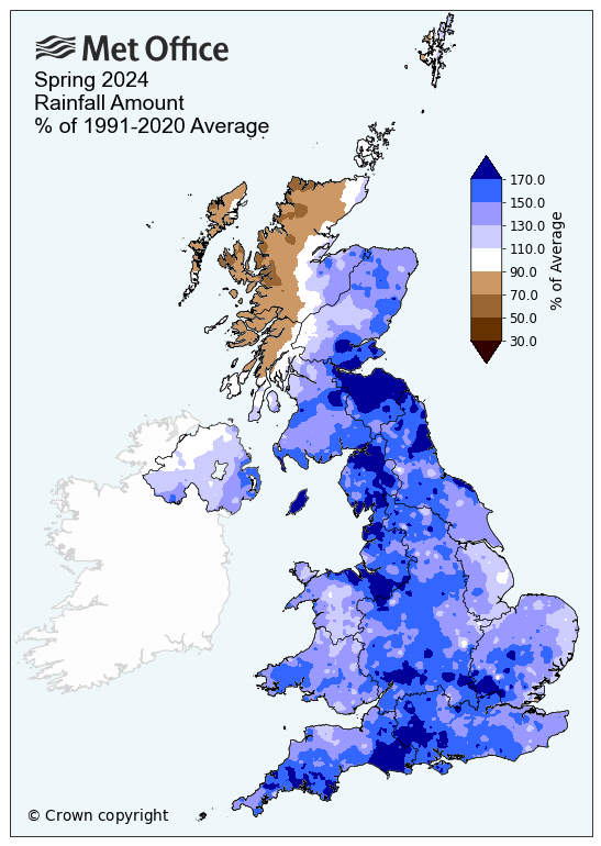
This month was part of the warmest spring on record, with the UK experiencing its sixth wettest spring overall and the wettest since 1986. The UK saw 301.7mm of rain over spring, 32% more than average. England and Wales had their respective fifth and eighth wettest springs on record.

Solar storms lit up the sky
In May, the strongest solar storm in 20 years lead to many people in the UK catching a glimpse of the aurora borealis. The display was thanks to the natural solar cycle, the storm’s high geomagnetic activity rating made the northern lights visible as far south as Cornwall.
A cool summer
The UK experienced the coolest summer since 2015, with an average mean temperature for the UK of 14.37°C, which is 0.22°C cooler than the long-term average. The last time the mean temperature was this low was in 2015, when the summer’s average was 13.91°C.
Wet September and Autumn for England
There were huge rainfall differences across the UK through Autumn, with England seeing far more than Scotland and Northern Ireland in particular. Gloucestershire for example, has had its wettest Autumn since the series began in 1836. Autumn started off wet, with a succession of low-pressure systems bringing exceptionally heavy rainfall to southern and central England in the latter part of September, and ten English counties experienced their wettest September on record. For Bedfordshire and Oxfordshire, September 2024 was the wettest calendar month the counties have experienced, in a series dating back to 1836.

Three named storms in three months
In October Storm Ashley, the first named storm of the season, brought with it winds of more than 80 mph.
November saw the arrival of Storm Bert, which brought heavy rain, snow, and strong winds to large swathes of the country. Locations in South Wales and Devon recorded over 150mm of rain during the storm. Approximately three-quarters of the whole-month November average rainfall fell fairly widely in a swathe from Gwent to Wiltshire to Northamptonshire, while the Oxfordshire / Northamptonshire border area received their whole month average rainfall, or more.
December meant Darragh, a storm that brought wind speeds of up to 90 mph, particularly affecting coastal areas and higher elevations. Some areas of the UK experienced over 50mm of rain in a 24-hour period.
#StormDarragh has brought increasingly strong winds overnight, but they are set to peak in the next few hours across parts of Wales and southwest England 🌬️
— Met Office (@metoffice) December 7, 2024
Stay safe if you are out this morning, and keep up to date with the latest warnings ⚠️
👉 https://t.co/j7ojlIej4g pic.twitter.com/Vg3O770gyd
Annual statistics for 2024
This year’s provisional 2024 annual weather and climate statistics for the UK will be available on 2 January 2025, along with the full UK State of the Climate Report later in the year.
From a global perspective, 2024 is expected to be the warmest year on record, now almost certain to exceed 1.5°C above pre-industrial levels for the first time. This follows on from the record-breaking 1.45°C in 2023, the previous warmest year on record.
The Met Office outlook for 2025 suggests that it is likely to be one of the three warmest years for global average temperature, falling in line just behind 2024 and 2023.
Find out more
- 2024 provisional weather and climate statistics will be released on 2 January 2025
- Met Office HadCRUT data for 2024 global average temperature will be published at the start of 2025
- Find climate statistics for previous months, seasons and years
- Read about the 2025 global outlook
- Read the report: State of the UK Climate 2023 - published 25 July 2024, and look out for 2024 report in July 2025


