The Hollywood studios of southern California are renowned for creating dramatic storylines. But sometimes the region produces events which rival anything from a film producer’s imagination.
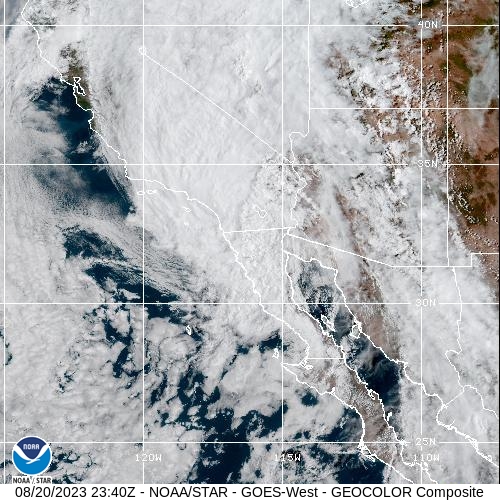
Tropical Storm Hilary – a former hurricane – is bringing intense rainfall to the South Western United States. So much rain is forecast that some locations in southern California and southern Nevada could see their average annual rainfall in a single 24-hour period.

Hilary crossed the border in southern California earlier this morning. The system has weakened to a ‘post-tropical depression’ bringing continued heavy rainfall as it moves northwards inland across the state’s deserts and mountains. Hilary will continue into Nevada, Oregon, Idaho and Montana.
The expected threats affecting the region will include flash flooding, and rapidly rising rivers. In such a normally arid region landslides are an ongoing threat in some locations.
Rainfall accumulations
Dr Julian Heming is a Met Office expert on tropical cyclones. He said: “Although Hilary reached hurricane status, its greatest impacts now will be the heavy rainfall. Forecasters are expecting rainfall accumulations as high as 150-250mm for parts of the region and up to 75mm further north across the Western United States.
“The average August rainfall for the affected areas is generally less than 25mm. This creates the potential that some locations could see a year’s worth of rainfall in a single day.”
Looking at the outlook for the rest of the year and into 2024, forecasters are considering the influence of El Niño – a natural cycle of warming which occurs every few years in the eastern Tropical Pacific. Julian added: “El Niño, which is developing now, promotes more frequent and stronger hurricanes in the eastern Pacific. A significant proportion of storms moving this far north have been in El Niño years including ‘Nora’, the last one to reach California in 1997.”
Those with a longer memory will recall 1976 when ‘Kathleen’ took a similar track and produced severe flooding and widespread impacts across southern California.
Is there a link to climate change?
Climate modelling suggests that tropical cyclones could become more intense as a result of climate change. This is principally driven by warmer oceans as a result of climate change.
As the atmosphere warms, tropical cyclones will be able to hold more water, resulting in more intense rainfall events, which can be prolonged if a tropical cyclone stalls near the coast.
This research – led by Columbia University with support from Dr Malcolm Roberts from the Met Office – shows that the rapid-intensification of tropical cyclones is likely to increase in frequency.
The paper summarises that tropical cyclones are challenging features for climate models to resolve, so further research and review is still needed to fully understand the impact of climate change on tropical cyclones.


