Polar Vortex
The polar vortex is a circulation of winds high up in the stratosphere.
What is the Polar Vortex?
The polar vortex is a circulation of winds high up in the stratosphere, up to 30 miles (50 km) above the earth. It is present in winter, and is not a new phenomenon, scientists have known about it for many years.
The winds regularly exceed 155 miles per hour (250 km per hour) – the strength of the winds in the strongest hurricanes (known as Category 5).
During the winter it can strengthen and weaken. These changes exert an influence lower down in the atmosphere and ultimately on our weather.
How does the Polar Vortex affect our weather?
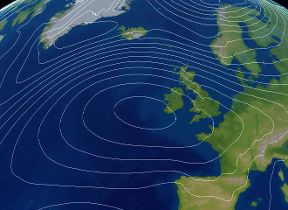
A strong polar vortex favours a strong jet stream. The jet stream is a fast moving ribbon of air around 5 to 7 miles (8 to 11km) above the earth that drives weather systems from the Atlantic towards the UK.
Conversely, when the polar vortex weakens, the jet stream also tends to weaken and become distorted.
In a typical UK winter, the jet stream brings winds from the west giving us our mild, damp climate.
With a stronger jet stream, stormy and very wet weather tends to occur. A weaker jet stream allows more frequent spells of northerly or easterly winds to affect the UK and in winter these bring very cold air from the Arctic and continental Europe.
Sometimes the polar vortex can even break down entirely, in an event called a ‘Sudden Stratospheric Warming’. This has been linked to many spells of cold winter weather in recent years.
So, changes in the polar vortex in the stratosphere can affect the strength of the jet stream and as a result whether we get milder or colder weather in winter.


