HadISDH - gridded global surface humidity dataset
HadISDH is a global gridded monthly mean surface humidity dataset. Quality
controlled and homogenised / bias adjusted monthly mean anomalies (relative
to a 1991-2020 base period) are provided alongside uncertainty
estimates (observation and gridbox sampling). Actual values, climatological
mean and standard deviation and no. observations are also provided. The
dataset begins in January 1973 and is updated annually.
HadISDH.land is a global gridded monthly mean land surface humidity
dataset based on the quality controlled sub-daily
HadISD dataset which
is in turn based on the
ISD dataset
from NOAA's
NCEI. Hourly dew poinbt
temperature and air temperature are converted to various humidity variables
and then averaged to monthly values. These are homogenised and averaged over
5° by 5° degree gridboxes for each month.
HadISDH.marine is a global gridded monthly mean ocean surface
humidity dataset. Hourly in situ dew point temperature and marine air
temperature data from ships are taken from
ICOADS. These are then converted to various humidity variables,
quality controlled, bias adjusted and averaged over 5° by 5° degree
gridboxes for each month.
HadISDH.blend is a global gridded monthly mean land and marine
surface humidity dataset combining HadISDH.land and HadISDH.marine.
HadISDH.extremes is a global gridded monthly mean land
surface humidity dataset. It builds upon HadISDH.land providing a monthly gridded product of
wet and dry bulb temperature extremes indices for monitoring heat extremes over land.
LATEST VERSIONS:
HadISDH.land.4.6.1.2024f covers January 1973 to December 2024.
Update Document.
HadISDH.marine.1.6.1.2024f covers January 1973 to December 2024.
Update Document.
HadISDH.blend.1.5.1.2024f covers January 1973 to December 2024.
HadISDH.extremes.1.2.0.2024f covers January 1973 to December 2024.
Update Document.
For previous versions please contact the dataset
maintainers.
Gridded products are available for 6 humidity variables in addition to
temperature and 29 extremes indices:
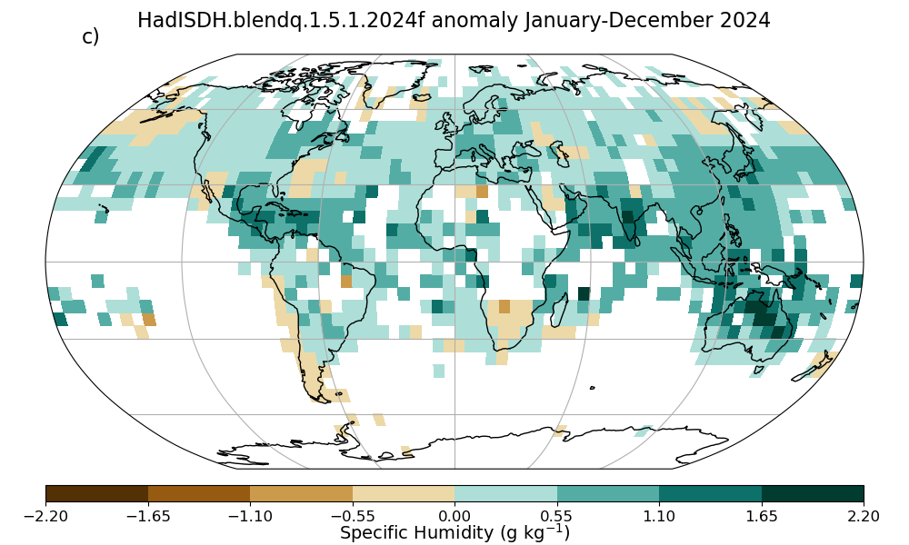
- Specific humidity (q), expressed in g kg-1. The
ratio of the mass of water vapour to the mass of moist air.
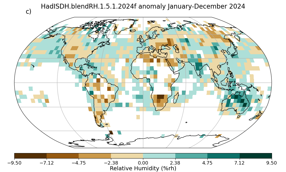
- Relative humidity (RH), expressed as a percentage (%rh). The
amount of water vapour in the air compared to how much water could
potentially be held as a vapour at that temperature.
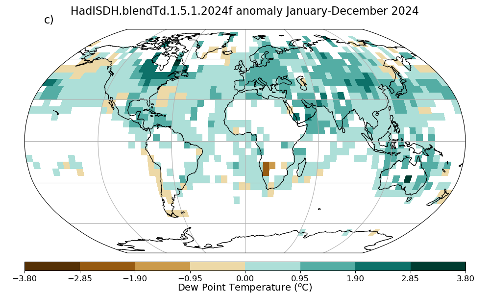
- Dew point temperature (Td), expressed in °C.
The temperature at which the air becomes saturated at that current
level of water vapour, measured by artificially cooling a surface
until water condenses onto it.
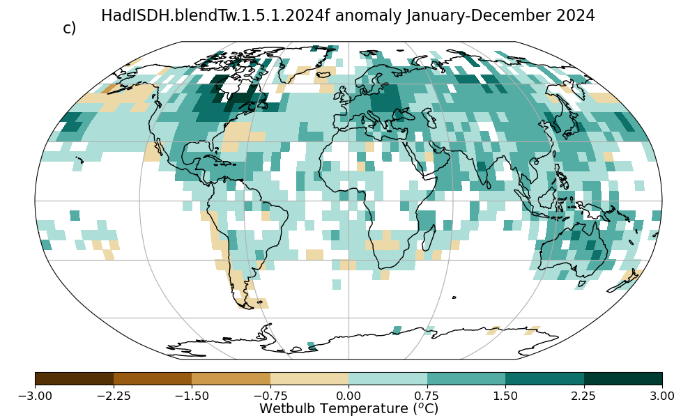
- Wet bulb temperature (Tw), expressed in °C.
The amount of evaporative cooling of a thermometer in a moistened
wick. Air that is not saturated will evaporate water from the wick,
cooling the 'wet bulb' thermometer.
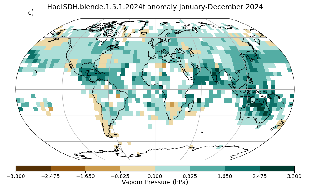
- Vapour pressure (e), expressed in hPa. The partial
pressure exerted by water vapour alone.
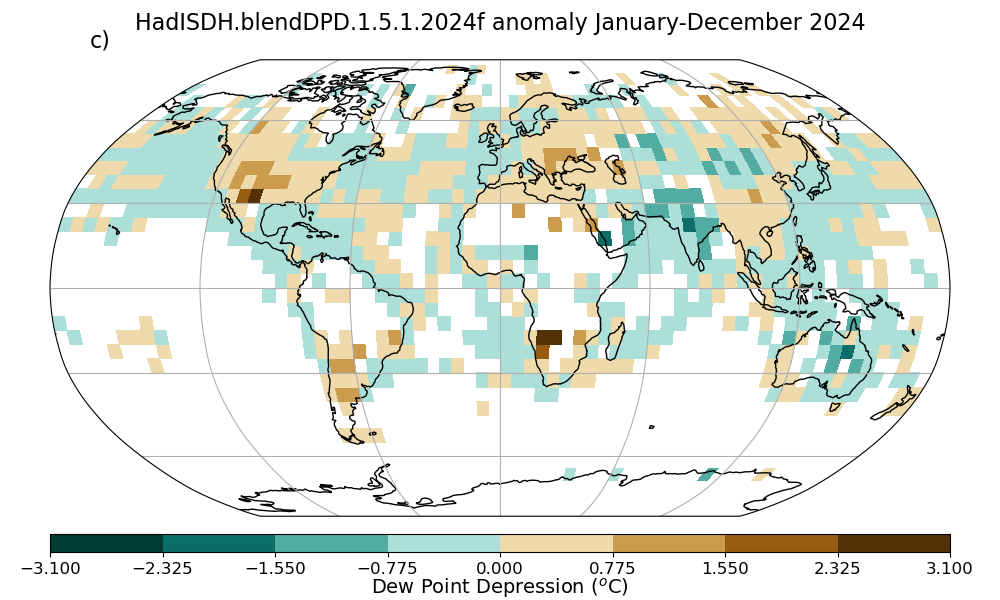
- Dew point depression (DPD), expressed in °C. The amount the
air has to be cooled by to reach its dew point temperature.
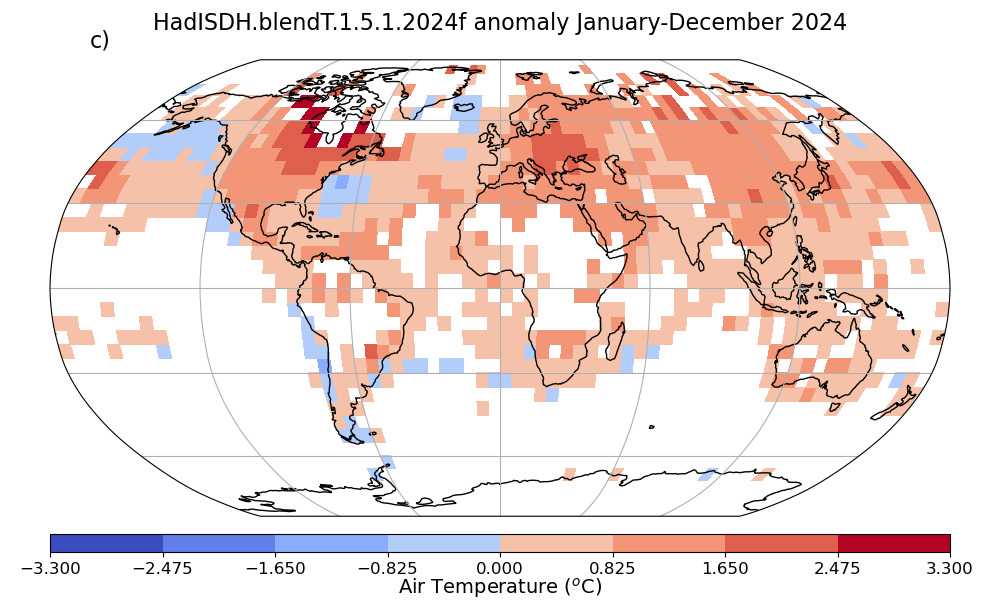
- Temperature (T), expressed in °C. The temperature
measured by the dry bulb thermometer.
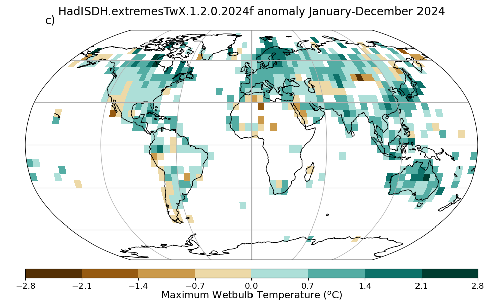
- Maximum wet bulb temperature (TwX), expressed in °C.
Gridbox median of station month maxima of daily maximum Tw.
- Minimum wet bulb temperature (TwN), expressed in °C.
Gridbox median of station month minima of daily minimum Tw.
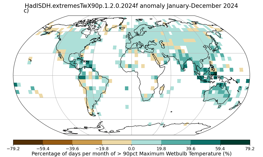
- 90th percentile maximum wet bulb temperature exceedance (TwX90p),
expressed in % of days per month. Gridbox mean of station percentages of days per month
where the daily maximum Tw exceeds the climatological 90th percentile
of daily maxima.
- 10th percentile maximum wet bulb temperature exceedance (TwX10p),
expressed in % of days per month. Gridbox mean of station percentages of days per month
where the daily maximum Tw is lower than the climatological 10th percentile
of daily maxima.
- 90th percentile mean wet bulb temperature exceedance (TwM90p),
expressed in % of days per month. Gridbox mean of station percentages of days per month
where the daily mean Tw exceeds the climatological 90th percentile of
daily means.
- 90th percentile minimum wet bulb temperature exceedance (TwN90p),
expressed in % of days per month. Gridbox mean of station percentages of days per month
where the daily minimum Tw exceeds the climatological 90th
percentile of daily minima.
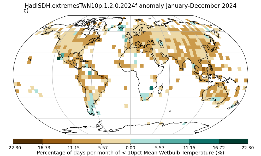
- 10th percentile minimum wet bulb temperature exceedance (TwN10p),
expressed in % of days per month. Gridbox mean of station percentages of days per month
where the daily minimum Tw is lower than the climatological 10th
percentile of daily minima.
- 10th percentile mean wet bulb temperature exceedance (TwM10p),
expressed in % of days per month. Gridbox mean of station percentages of days per month
where the daily mean Tw is lower than the climatological 10th
percentile of daily means.
- 25 °C maximum wet bulb temperature exceedance (TwX25),
expressed in % of days per month. Gridbox mean of station percentages of days per month
where the daily maximum Tw is equal to or exceeds 25 °C.
- 27 °C maximum wet bulb temperature exceedance (TwX27),
expressed in % of days per month. Gridbox mean of station percentages of days per month
where the daily maximum Tw is equal to or exceeds 27 °C.
- 29 °C maximum wet bulb temperature exceedance (TwX29),
expressed in % of days per month. Gridbox mean of station percentages of days per month
where the daily maximum Tw is equal to or exceeds 29 °C.
- 31 °C maximum wet bulb temperature exceedance (TwX31),
expressed in % of days per month. Gridbox mean of station percentages of days per month
where the daily maximum Tw is equal to or exceeds 31 °C.
- 33 °C maximum wet bulb temperature exceedance (TwX33),
expressed in % of days per month. Gridbox mean of station percentages of days per month
where the daily maximum Tw is equal to or exceeds 33 °C.
- 35 °C maximum wet bulb temperature exceedance (TwX35),
expressed in % of days per month. Gridbox mean of station percentages of days per month
where the daily maximum Tw is equal to or exceeds 35 °C.
- Maximum maximum wet bulb temperature (TwXX), expressed in °C.
Gridbox maximum of station month maxima of daily maximum Tw.
- Maximum dry bulb temperature (TX), expressed in °C.
Gridbox mean of station month maxima of daily maximum T.
- Minimum dry bulb temperature (TN), expressed in °C.
Gridbox mean of station month minima of daily minimum T.
- 90th percentile maximum dry bulb temperature exceedance (TX90p),
expressed in % of days per month. Gridbox mean of station percentages of days per month
where the daily maximum T exceeds the climatological 90th percentile
of daily maxima.
- 90th percentile mean dry bulb temperature exceedance (TM90p),
expressed in % of days per month. Gridbox mean of station percentages of days per month
where the daily mean T exceeds the climatological 90th percentile of
daily means.
- 10th percentile minimum dry bulb temperature exceedance (TN10p),
expressed in % of days per month. Gridbox mean of station percentages of days per month
where the daily minimum T is lower than the climatological 10th
percentile of daily minima.
- 10th percentile mean dry bulb temperature exceedance (TM10p),
expressed in % of days per month. Gridbox mean of station percentages of days per month
where the daily mean T is lower than the climatological 10th
percentile of daily means.
- 25 °C maximum dry bulb temperature exceedance (TX25),
expressed in % of days per month. Gridbox mean of station percentages of days per month
where the daily maximum T is equal to or exceeds 25 °C.
- 30 °C maximum dry bulb temperature exceedance (TX30),
expressed in % of days per month. Gridbox mean of station percentages of days per month
where the daily maximum T is equal to or exceeds 30 °C.
- 35 °C maximum dry bulb temperature exceedance (TX35),
expressed in % of days per month. Gridbox mean of station percentages of days per month
where the daily maximum T is equal to or exceeds 35 °C.
- 40 °C maximum dry bulb temperature exceedance (TX40),
expressed in % of days per month. Gridbox mean of station percentages of days per month
where the daily maximum T is equal to or exceeds 40 °C.
- 45 °C maximum dry bulb temperature exceedance (TX45),
expressed in % of days per month. Gridbox mean of station percentages of days per month
where the daily maximum T is equal to or exceeds 45 °C.
- 50 °C maximum dry bulb temperature exceedance (TX50),
expressed in % of days per month. Gridbox mean of station percentages of days per month
where the daily maximum T is equal to or exceeds 50 °C.
- 18 °C minimum dry bulb temperature exceedance (TN18),
expressed in % of days per month. Gridbox mean of station percentages of days per month
where the daily minimum T is equal to or exceeds 18 °C.
- Maximum maximum dry bulb temperature (TXX), expressed in °C.
Gridbox maximum of station month maxima of daily maximum T.
Brief description of the data
Land
HadISDH utilises simultaneous subdaily temperature and dew point
temperature data from >5600 quality controlled HadISD stations that have
sufficiently long records. Further information on the quality control tests
and HadISD can be found
here. All humidity variables are calculated at hourly resolution and
monthly means are created.
Monthly means are homogenised to detect and adjust for features within the
data that do not appear to be of climate origin. While unlikely to be perfect,
this process does help remove large errors from the data an improve robustness
of long-term climate monitoring. We have used NCEI's
Pairwise
Homogenisation Algorithm directly on DPD and T. We have designed an
indirect PHA method (ID PHA) whereby changepoints detected in DPD and T
are used to make adjustments to q, e, Tw and
RH. Changepoints from DPD are also applied to T. Td
is derived from homogenised T and DPD. Further information can be found
here. Stations with very large (>5 °C in
T and Td, > 3 g kg-1 in q and > 15 %rh in RH) adjustments applied
are removed.
Measurement, climatological and homogeneity adjustment uncertainty is
estimated for each month.
Climatological averages over the 1991 to 2020 period are calculated
and monthly mean climate anomalies obtained. These anomalies (in addition to
climatological mean and standard deviation, actual values and uncertainty
components) are then averaged over 5° by 5° gridboxes centred on
-177.5°W and -87.5°S to 177.5°E and 87.5°N.
Given the uneven distribution of stations over time and space, sampling
uncertainty is estimated for each gridbox month. Further in formation on
uncertainty estimates can be found here.
Marine
HadISDH.marine utilises simultaneous subdaily air temperature and dew point
temperature data from ships, moored buoys and ocean platforms from
ICOADS.3.0.0 and ICOADS.3.0.2
(Freeman et al., 2016). All humidity variables are calculated at hourly
resolution.
Hourly humidity and temperature values are quality controlled to to remove
gross random errors (bad locations, bad timings, climatological outliers,
neighbourhood outliers). Bias adjustments are also applied to the hourly data
to account for increasing ship heights over time and changing proportions of
poorly ventilated instruments. The data are then averaged over 5° by 5°
gridboxes centred on -177.5°W and -87.5°S to 177.5°E and 87.5°N
for each month as anomalies and actual values. No interpolation is applied.
Data are available as monthly mean anomaly values relative to 1991 to
2020 climatology, actual values, climatologies and a climatological
standard deviation.
Uncertainty has been assessed at the observation level for measurement
uncertainty, rounding uncertainty, climatology uncertainty, height adjustment
uncertainty and ventilation adjustment uncertainty. These are made available
at the gridbox monthly mean level along with spatio-temporal sampling
uncertainty.
Blend
HadISDH.blend combines HadISDH.land and HadISDH.marine. Where both land and
marine gridboxes are present a weighted average is taken based on land
fraction with a lower limit of 0.25/0.75 enforced when either the land
fraction is below 25% or above 75%.
Extremes
HadISDH utilises simultaneous subdaily wet bulb and dry bulb temperature
from ~4500 quality controlled HadISD stations that have
sufficiently long records. Further information on the quality control tests
and HadISD can be found
here. The wet bulb temperature is calculated from the dry bulb temperature
dew point temperature, with climatological surface pressure from ERA5 at hourly
resolution and monthly indices are created.
Monthly indices are not homogenised. However, inhomogeneity information from the
equivalent HadISDH.land monthly means is used to provide homogeneity scores
for each gridbox month. These can be used to filter the data to remove gridbox
months that are affected by large inhomogeneities. We recommend screening to
remove gridboxes with homogeneity scores (HQ Flag) of >= 7. While unlikely to be
perfect, this does help remove large errors from the data an improve robustness
of long-term climate monitoring.
Climatological averages over the 1991 to 2020 period are calculated
and monthly climate anomalies obtained. These anomalies (in addition to
climatological mean and standard deviation and actual values) are then averaged
over 5° by 5° gridboxes centred on
-177.5°W and -87.5°S to 177.5°E and 87.5°N.
Keep in touch
Follow us on twitter:
@metofficeHadOBS for updates, news and announcements.
For more detailed information, follow our HadISDH
blog. Here we describe bug
fixes, routine updates and other exploratory analysis.
|
2024 ANNUAL ANOMALIES (1991-2020 climatology)
|
|
Commercial and media enquiries
You can access the Met Office Customer Centre, any time of the
day or night by phone, fax or e-mail. Trained staff will help you
find the information or products that are right for you.
Contact
the Met Office Customer Centre
|
References
When using the datasets please use the following citations
and state the version used:
Land
Willett, K. M., Dunn, R. J. H., Thorne, P. W., Bell, S., de
Podesta, M., Parker, D. E., Jones, P. D., and Williams Jr., C. N.:
HadISDH land surface multi-variable humidity and temperature
record for climate monitoring, Clim. Past, 10, 1983-2006,
doi:10.5194/cp-10-1983-2014, 2014.
Main Text PDF file 2.6Mb
Supplementary
Material PDF file 1.8Mb
Smith, A., N. Lott, and R. Vose, 2011: The Integrated Surface
Database: Recent Developments and Partnerships. Bulletin of the
American Meteorological Society, 92, 704\u2013708,
doi:10.1175/2011BAMS3015.1.
Available from BAMS
We strongly recommend that you read the Willett et al. (2014)
paper before making use of the data. Additionaly information can be
found in the reference for version 1.0.0:
Willett, K. M., Williams Jr., C. N., Dunn, R. J. H., Thorne, P.
W., Bell, S., de Podesta, M., Jones, P. D., and Parker D. E., 2013:
HadISDH: An updated land surface specific humidity product for
climate monitoring. Climate of the Past, 9, 657-677,
doi:10.5194/cp-9-657-2013.
PDF file (5.4MB)
Marine
Willett, K. M., Dunn, R. J. H., Kennedy, J. J., and Berry, D. I.
2020: Development of the HadISDH marine humidity climate
monitoring dataset. Earth System Science Data. 12, 2853-2880,
doi.org/10.5194/essd-12-2853-2020.
Main Paper (PDF 7.6 Mb)
Supplement
(PDF 3.5 Mb)
Freeman, E., S.D. Woodruff, S.J. Worley, S.J. Lubker, E.C. Kent,
W.E. Angel, D.I . Berry, P. Brohan, R. Eastman, L. Gates, W.
Gloeden, Z. Ji, J. Lawrimore, N.A. Rayner, G. Rosenhagen, and S. R.
Smith, 2016: ICOADS Release 3.0: A major update to the historical
marine climate record. Int. J. Climatol. (doi:10.1002/joc.4775).
Available from IJC
Blend
Please use all of the above references.
Extremes
Willett, K, 2023: HadISDH.extremes Part 1: a gridded wet bulb
temperature extremes index product for climate monitoring. Advances in
Atmospheric Sciences, doi: 10.1007/s00376-023-2347-8.
http://www.iapjournals.ac.cn/aas/en/article/doi/10.1007/s00376-023-2347-8
Part 1 (PDF x.x Mb)
Willett, K. 2023: HadISDH.extremes Part 2: exploring humid
heat extremes using wet bulb temperature indices. Advances in Atmospheric
Sciences, doi: 10.1007/s00376-023-2348-7.
http://www.iapjournals.ac.cn/aas/en/article/doi/10.1007/s00376-023-2348-7
Part 2 (PDF x.x Mb)
|
|
Useful Diagnostics
Figures from the Willett et al.
2014 paper.
Figures from the Willett et al.
2013 paper.
Figures from State of the Climate
and IPCC monitoring plots.
Decadal Trend maps for each variable:
LAND;
MARINE;
BLEND;
EXTREMES.
Annual and monthly average timeseries for the globe, hemispheres
and tropics, including uncertainty estimates:
LAND;
MARINE;
BLEND;
EXTREMES.
Annual anomaly maps from 1973 onwards for specific humidity:
LAND;
MARINE;
BLEND.
Annual anomaly maps from 1973 onwards for relative humidity:
LAND;
MARINE;
BLEND.
Annual anomaly maps from 1973 onwards for vapour pressure:
LAND;
MARINE;
BLEND.
Annual anomaly maps from 1973 onwards for dew point temperature:
LAND;
MARINE;
BLEND.
Annual anomaly maps from 1973 onwards for wet bulb temperature:
LAND;
MARINE;
BLEND.
Annual anomaly maps from 1973 onwards for air temperature:
LAND;
MARINE;
BLEND.
Annual anomaly maps from 1973 onwards for dew point depression:
LAND;
MARINE;
BLEND.
Extremes index annual anomaly maps from 1973 onwards for:
TwX;
TwX90p;
TwN10p.
Our versioning system is of the form HadISDH.type.X.Y.Z.1234i. 'type' refers
to the variable (e.g., landq=specific humidity). 'X' is for a major change and
would be accompanied by a peer-reviewed paper or Met Office Technical Note.
'Y' is a more minor change, e.g., in one of the QC tests or homogenisation
algorithms and would be described in a tech-note. 'Z' is a small change, for
example addition or changes to data in the past. The last complete year of the
dataset is given by '1234', and the final character shows if the dataset is
f-final or p-preliminary. Therefore HadISDH.landq.2.0.0.2013p is the preliminary
version of the dataset containing data up to the end of 2012.
Dataset and Diagnostic Creation Code
The Python 3 code used (excluding quality control, homogenisation and
regional average uncertainty estimates) was written by
Kate
Willett.
Dataset produced in collaboration with:


