Tragedy and warnings – the origins of the Shipping Forecast
From saving lives at sea to becoming part of Britain's cultural fabric, the Shipping Forecast has become a national institution and in 2025, we mark 100 years since its first BBC broadcast.
Discover the story behind this iconic broadcast, from its origins as a revolutionary storm warning system, to its evolution into one of the world's longest-running weather forecasting services.
The Royal Charter storm of 1859
A severe, slow-moving storm, later named the Royal Charter Gale, hit the Irish Sea on the night of 25 October in 1859. Wind speeds in the adjoining River Mersey were higher than any previously recorded.
800 people were killed and 133 ships destroyed, with 90 more badly damaged. The most famous ship to be lost during the night was the steam clipper, Royal Charter, which foundered on the coast of Anglesey with the loss of over 450 lives.

The above image shows the original weather chart produced by Met Office founder Robert FitzRoy to depict the Royal Charter Gale in October 1859.
FitzRoy’s warning system
The wreck gained much coverage in the national press and focused attention on the need for gale warnings to reduce further such losses. Robert FitzRoy, founder of the fledgling Meteorological Office, which had been collecting observations from around the British coastline since 1854, believed that his department could provide such a service. He produced a detailed report with charts to prove that the storm could have been tracked and its path predicted.
Through his analyses of the Royal Charter and other storms, FitzRoy demonstrated the validity of his models and proposed a national storm warning system. There was much doubt amongst the scientific establishment that the weather could be predicted in any meaningful way, but the government permitted FitzRoy to test his new science of weather forecasting and to establish a Gale Warning service.
From 1911, the gale warnings also began to be broadcast to shipping vessels approaching UK waters from the northeast Atlantic. A little like modern National Severe Weather Warnings, warnings were only issued if poor weather was likely, but the service became the ancestor of the modern Shipping Forecast.

The early years (1861-1911)
Observations were collected from around the coasts and sent to the Meteorological Office in London. There they were analysed and if a gale was likely, a warning was sent to the relevant coast. A visual system of cones and drums was used to warn shipping vessels. The first warning was issued in February 1861. The service was curtailed temporarily on 7 December 1866 following the death of FitzRoy and the outcome of the controversial Galton report. Public pressure and questions in parliament forced a restart from 30 November 1867, and the first warning was issued on 10 January 1868. The service then continued without pause, except for during wartime, when all weather information was secret. The use of visual signals only ceased in 1984, due to a change in maritime law requiring all vessels to be equipped with a radio.
Forties, Dogger, Wight - Weather Shipping is born
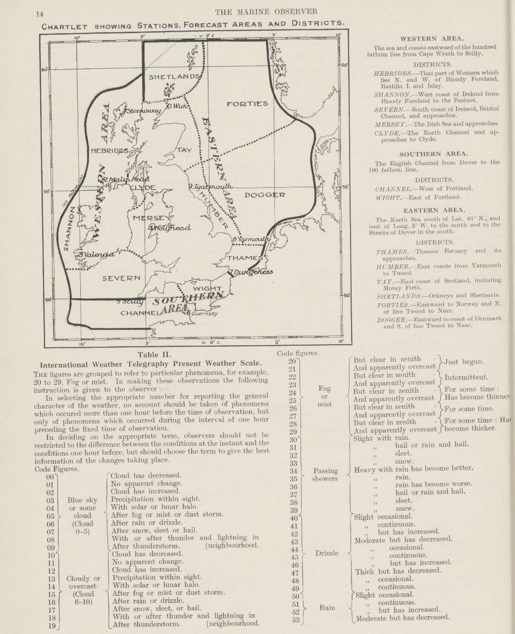
On 1 January 1924, in appreciation of the valuable help given to the meteorological service by the radio weather reports from ships, a weather bulletin called Weather Shipping was started. It was broadcast twice daily at 0900 and 2000 GMT, from the powerful Air Ministry station G.F.A. in London, on a wavelength of 4,100 metres using CW (continuous wave) transmission which used morse code and was capable of being received at a distance of up to 2,400 miles to the west and some 2,000 miles to the south.
There were originally 14 forecast areas. Over time they have changed in number, area and shape but Forties, Dogger, Thames, Wight, Shannon, Hebrides and Humber have been with us since the very first Shipping Forecast transmission.
The general pattern of the forecast has also not changed dramatically. It works clockwise around the country, often combining areas e.g. ‘Thames, Dover, Wight’ and gives current gale warnings in force, a general synopsis of current conditions across the whole Shipping Forecast area, and then forecasts by area for the next 12 hours, including an indication of conditions for the following 12 hours.
The key differences from 1924 are that the modern Shipping Forecast starts by listing any gale warnings currently in force and early editions now include a coastal waters forecast, whilst the original shipping forecast began with the general weather synopsis and then included a series of actual observations in code from ten stations around the British Isles. These are still present but only in the 00:48 and 05:20 broadcasts.

Sea areas and stations as originally used in 1924.
1925 – from morse code to the BBC
The continuous wave transmissions were very valuable but could not be received by smaller vessels, and so a request was made for a more accessible method which could reach all shipping. At the same time, the farming community also requested specific agricultural forecasts and so in 1925, the BBC offered the use of their high power station at Daventry at 10:30am each morning for the issue of a special weather message for farmers and shipping. In July 1925, the new issue commenced consisting of a forecast for farmers, a general forecast, and the forecast for the sea areas taken from the Weather Shipping Bulletin.
Over the coming months, the service evolved and from October 1925, Weather Shipping (the Shipping Forecast) was broadcast as a service in its own right, with an evening broadcast added from January 1926.
Until 2024, the Shipping Forecast had been broadcast on BBC longwave radio services so the signal could be received clearly at sea. The forecast was broadcast on the BBC National Programme until September 1939, and then after the Second World War on the Home Service, followed by the BBC Light Programme (later BBC Radio 2) until November 1978. When BBC Radio 4 took over the longwave frequency from Radio 2 on 23 November 1978, the Shipping Forecast was moved to Radio 4 to keep it broadcasting on longwave. Transmission of the forecast only stopped during the second world war, when all weather information became a matter of national security. Broadcasting a forecast to shipping could help your allies, but it was also of significant use to your enemies.
During the COVID-19 pandemic, the forecast was reduced to three times per day and the time of the early forecast moved slightly. Although much which had changed remained in its new format after the pandemic, the Shipping Forecast rapidly reverted to the standard broadcast pattern as conditions returned to a more normalised state. Permanent change was only instituted with plans for the eventual retirement of BBC longwave transmitter.
As part of the BBC's plans to switch off the BBC Radio 4 longwave transmitter in April 2024, it reduced daily broadcasts of the Shipping Forecast to the FM simulcast schedule of twice on weekdays (00:48 and 05:20) and three times on weekends (00:48, 05:20 and 17:54).
‘Weather Shipping’ to the Shipping Forecast – the evolution of an icon
Over time, more Shipping Forecast areas were added and after World War Two, the area expanded to cover far more of the sea areas around the UK. Weather Shipping finally became known as the Shipping Forecast in 1954.
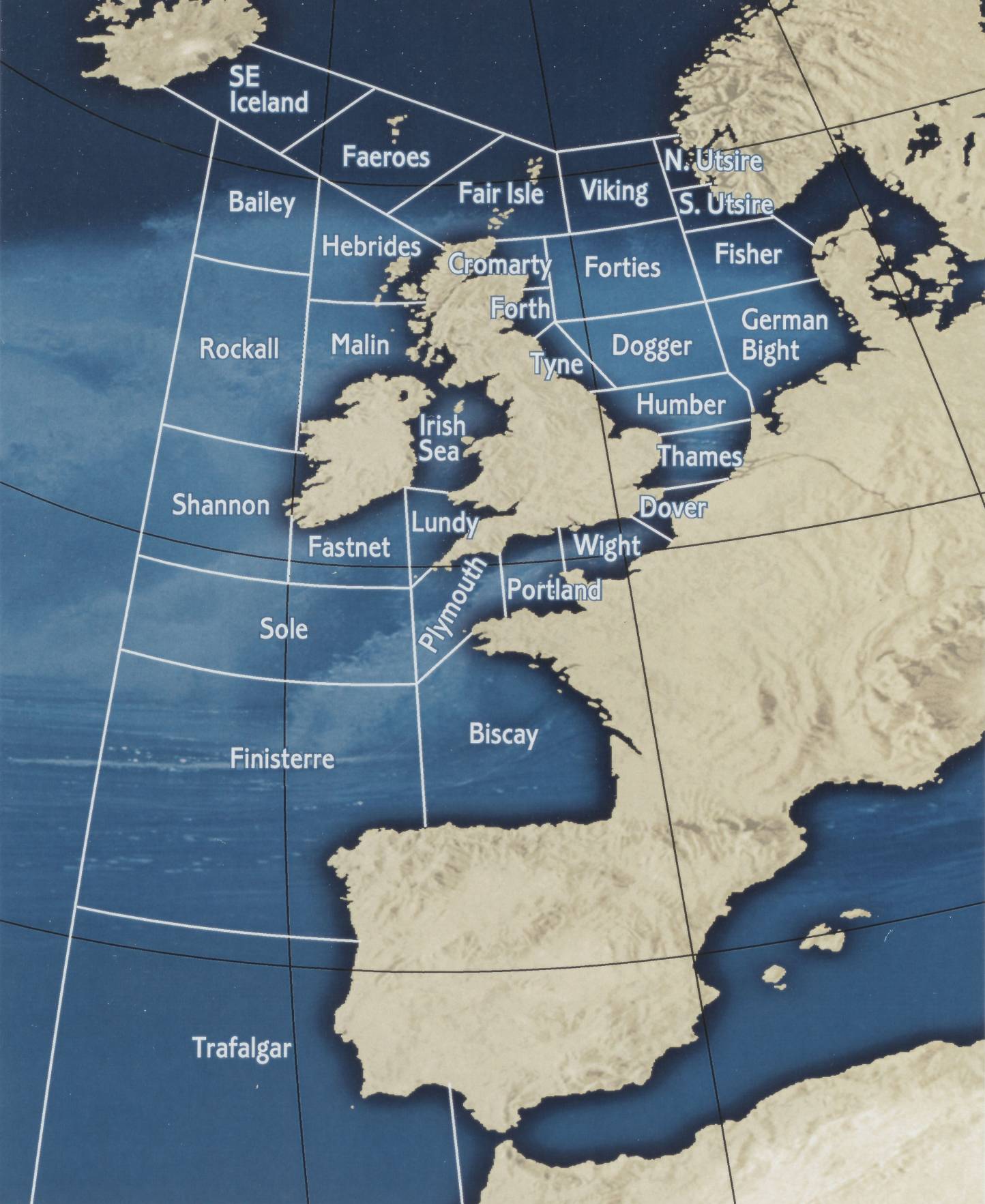
In 1949, many new areas and well-known names were added, including Rockall, Bailey and Fast Net, and in 1956, international agreements changed Heligoland to German Bight, divided Forties and Dogger to add Fisher and Viking and altered Iceland to southeast Iceland. In 1984 North Utsire and South Utsire were added.
The last major change to the Shipping Forecast map took place in 2002, when the sea area Finisterre was renamed FitzRoy in recognition of Vice-Admiral FitzRoy, founder of the Met Office and originator of the original storm warning service.
The names of the 31 areas are all drawn from geographical features including:
-
rivers e.g. Tyne, Humber, Thames and Shannon
-
fishing banks e.g. Dogger, Fisher, Forties, Sole and Bailey
-
coastal locations and Islands e.g. German Bight, North Utsire and South Utsire, Wight, Malin, Fair Isle and Faeroes
-
and marine features e.g. Fastnet Rock and Rockall Rock.

Shipping Forecast map areas 2001.
Safety and culture – the ongoing relevance of the Shipping Forecast
The Shipping Forecast remains a ‘safety to life’ service and is still valuable to mariners all around the UK coasts. It is produced by the Met Office on behalf of the Maritime and Coastguard Agency (MCA), who are responsible for the provision of Maritime Safety Information (MSI) to ships at sea, which includes the broadcast of warnings and forecasts.
But as well as its lifesaving link, the forecast has taken on a life of its own and has found a place in popular culture. The last moments of the classic 2011 Ashes cricket commentary were famously interrupted to enable the broadcast to go ahead on schedule for example.
The calming tones of the broadcast are widely used to aid sleep and indeed, the Shipping Forecast inspired the BBC Sounds ‘sleeping forecast’.
The forecast has been referenced by many bands, including Radiohead, The Prodigy, Manfred Mann, Jethro Tull and Blur. It has also been selected as a Desert Island Disc (the accompanying music – Sailing By, by Ronald Binge is also a popular choice). Interestingly, Sailing By has become synonymous with the Shipping Forecast, but was actually written as 'stock music' and was first used to accompany a programme about hot air balloons. The Shipping Forecast was also featured in the 2012 London Olympics opening ceremony.
Parodied versions have been featured on many radio shows and plays, and a version can also be heard in the restrooms of Rockfish restaurant chain. Snippets of forecasts have appeared on television and film, and in the popular multi-player online roleplaying video game ‘The Secret World’, where the Shipping Forecast plays over the radio in a London Underground station to help distinguish the British location from other worldwide settings in the game. There is even a three-bell change ringing method named ‘Shipping Forecast Singles’!
Learn more about the Shipping Forecast on this Google Arts and Culture Story.


