

Airfield climate data
Access airfield climate statistics at 47 UK airports, including occurrence of LVPs, temperature, cloud cover, weather types, visibility and wind.
The statistics on these pages are derived from weather observations made over a number of years by meteorological observers at each airfield.
Graphs of averages are then produced which help you understand the data. So, for example, the wind rose will show you the prevailing wind at each site. This will show you how often on average you might have problems with crosswinds. By looking at the different sites, you will be able to determine which of several airfields will best meet your needs.
This data is historical and provides an indication of average weather conditions at each site, consequently valid pre-flight briefing documentation still needs to be obtained for each flight.
The Charts
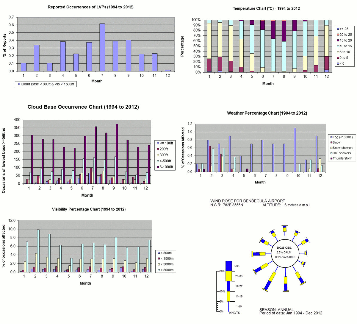
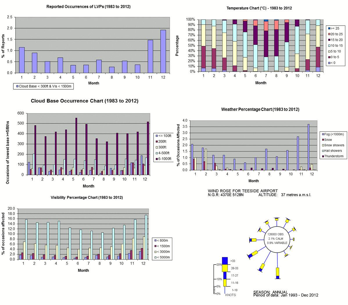
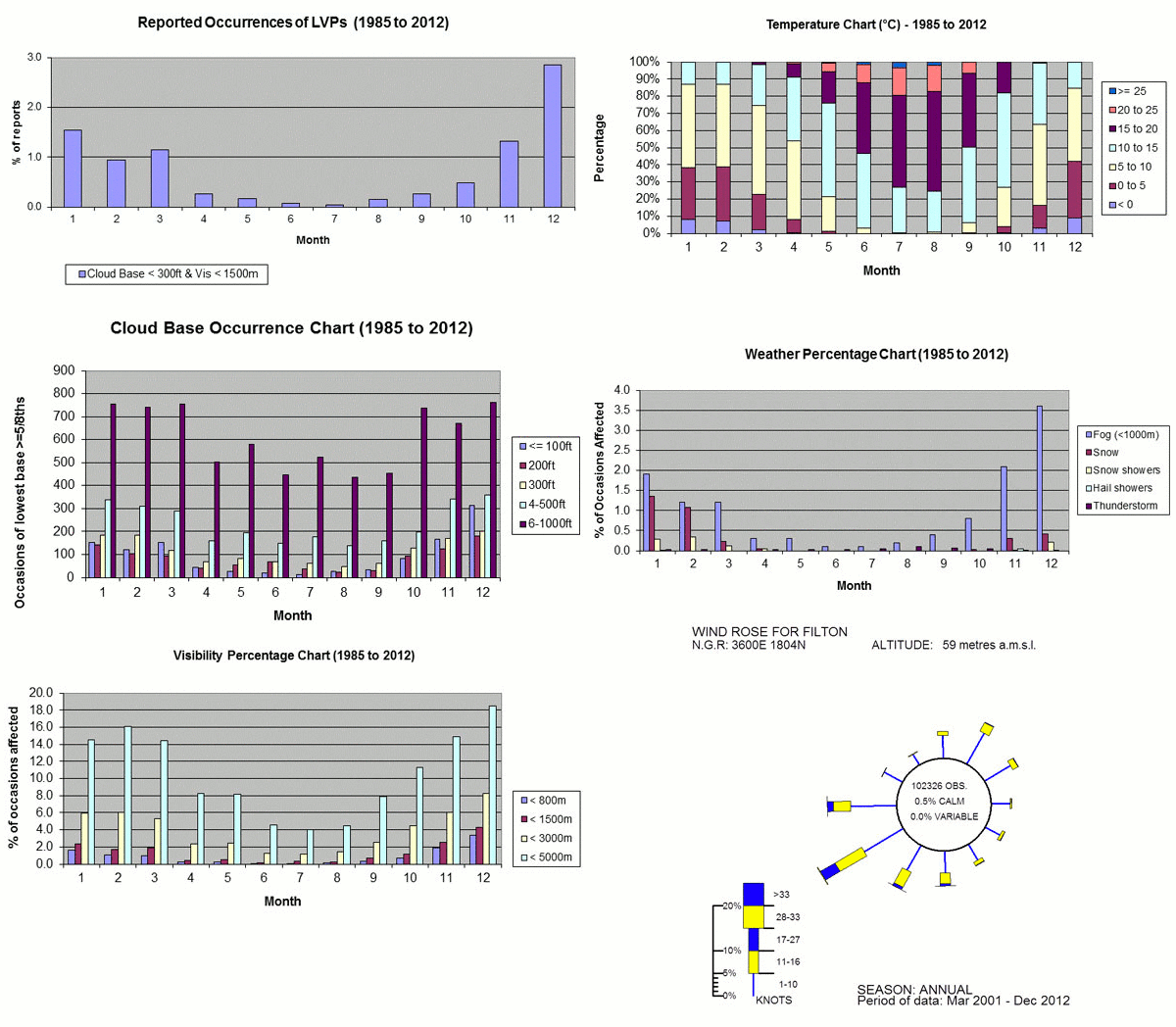
Occurrence of LVPs
(Low Visibility Procedures) - When the cloud base and/or surface visibility fall below certain limits (for example 1,500 m for visibility and 300 ft for cloud*), the operating conditions at the airport change and new rules are imposed. Some aircraft have restricted use in LVP conditions.
*airports are able to determine their own LVP thresholds, so these statistics should be regarded as a broad guide.
Temperature
This shows the percentage of occasions that the daily maximum temperature fell within certain ranges, by month. The sum total of these ranges always equals 100%. Temperatures are useful to pilots when considering fuel loads and icing.
Cloud-base Occurence
This displays the frequency occurrence, since the record began, that a cloud base (over half cover) fell below certain altitudes, by month. The relevance to pilots is due to the fact that their operating minima involves cloud bases.
Weather Percentage
This shows the percentage of days that certain important weather conditions were reported, by month. Weather such as fog, thunderstorms and snow are all important for pilots.
Visibility Percentage
This shows the percentage of occasions that the minimum visibility fell below certain limits, by month. Aircraft have operating minima and one criterion is visibility.
Wind Rose
This is a graphical representation showing the relationship between the frequency and speed of wind from compass point directions. Wind is important to pilots for example, when assessing likely cross wind components (the wind coming perpendicularly across the landing area, as opposed to headwind/tailwind). Operating conditions are reduced with crosswinds.
Available Airfields Map
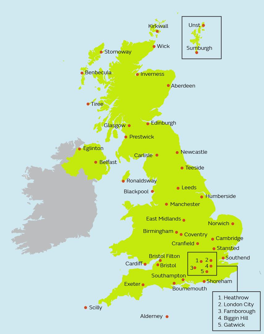
List of airports
Click on any airport to see its airfield climate statistics.
- Aberdeen
- Aldergrove (Belfast International)
- Alderney
- Benbecula
- Biggin Hill
- Birmingham
- Blackpool
- Bournemouth
- Bristol
- Cambridge
- Cardiff
- Carlisle
- Coventry
- Cranfield
- Durham Tees Valley
- Edinburgh
- Eglinton (City of Derry)
- East Midlands
- Exeter
- Farnborough
- Gatwick
- Glasgow
- Gloucester
- Heathrow
- Humberside
- Inverness
- Isles of Scilly (St Mary's)
- Kirkwall
- Leeds
- London City
- Manchester
- Newcastle
- Norwich
- Prestwick
- Ronaldsway
- Shoreham
- Southampton
- Southend
- Stansted
- Stornoway
- Sumburgh
- Tiree
- Unst
- Wick
Aberdeen

Aldergrove

Alderney

Benbecula
Biggin Hill

Birmingham

Blackpool

Bournemouth

Bristol

Cambridge

Cardiff

Carlisle

Coventry

Cranfield

Durham Tees Valley
Edinburgh

Eglinton (City of Derry)

East Midlands

Exeter

Farnborough

Gatwick

Glasgow

Gloucester

Heathrow

Humberside

Inverness

Isles of Scilly (St Mary's)

Kirkwall

Leeds

London City

Manchester

Newcastle

Norwich

Prestwick

Ronaldsway

Shoreham

Southampton
Southend

Stansted

Stornoway

Sumburgh

Tiree

Unst

Wick

Get in touch
Call us
We are available 24/7.
0370 900 0100Email us
Fill out this short form and we'll get back to you.
Contact Us formFollow us
Linkedin XGet in touch
Call us
We are available 24/7.
0370 900 0100Email us
Fill out this short form and we'll get back to you.
Contact Us form

