Fusing weather forecasts, machine learning and citizen observations to improve urban heat predictions
A new Met Office led paper demonstrates how machine learning algorithms can be used alongside UK weather forecasts and citizen-science observations to improve the predictions of urban heatwave temperatures across London.
Prediction of extreme temperatures in cities is particulary important given the number of people who live and work there, and the density of critical infrastructure in urban areas. This supports provision of day-to-day guidance to help people stay safe. On longer timescales, information on urban climate risks inform decision makers about future health and societal impacts, as well as aiding design of adaptive responses to climate change. The urban heat island (UHI) effect exacerbates heatwave temperature extremes in cities, with impacts on human health, building energy consumption and infrastructure.
Accurate forecasting of conditions within cities is challenging given the huge variety of natural and human land use and building types that can occur within relatively small areas. In the current generation of weather and climate models it is both difficult and computationally expensive to simulate the complex processes controlling neighbourhood-scale variations in temperature.
A Met Office led paper, published in the Royal Met Society’s Meteorological Applications journal, explored the possibility of fusing weather simulations with weather observations across London and using machine learning to improve the granularity of information that can be provided. The work was undertaken by Dr Lewis Blunn, from the Met Office urban-scale modelling group, alongside a team of PhD students at the University of Reading.
The Met Office’s operational UK temperature forecasts are simulated on a 1.5 km spaced grid, making this the upper limit at which spatial information is available. The machine learning method developed transforms the temperature forecasts to a 100 m spaced grid, greatly enhancing the level of detail at which information on temperature variations in cities can be provided. This is achieved by fusing operational weather forecast data with local weather observations collected through the Weather Observation Website (WOW) and higher resolution information on land use than is currently utilized in our operational forecasts (Figure 1). The study was made possible by citizens uploading their personal weather observations to the WOW platform, creating a unique dataset of high-density observations encompassing areas of cities which are sparsely sampled by professional observation sites. The proof-of-concept study focussed on 8 heatwave cases over London in the period 2019-2021 and assessed the performance of 3 possible machine learning algorithms.
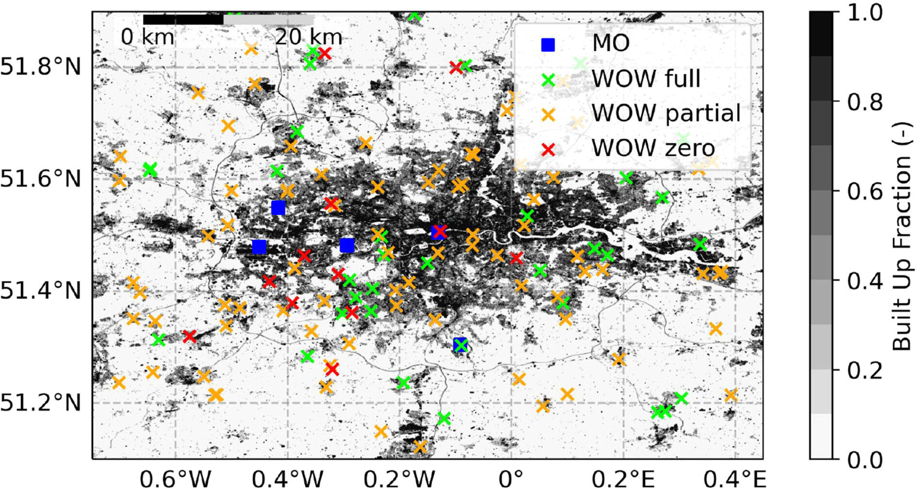
Figure 1: Illustration of the built up fraction over Greater London region on a grid with 100 m spacing (derived from the ESA World Cover dataset) with the locations of the 5 Met Office observation network sites (blue squares) together with citizen weather station locations with full, partial or no reporting data to the Weather Observations Website (WOW) during the heatwave periods considered.
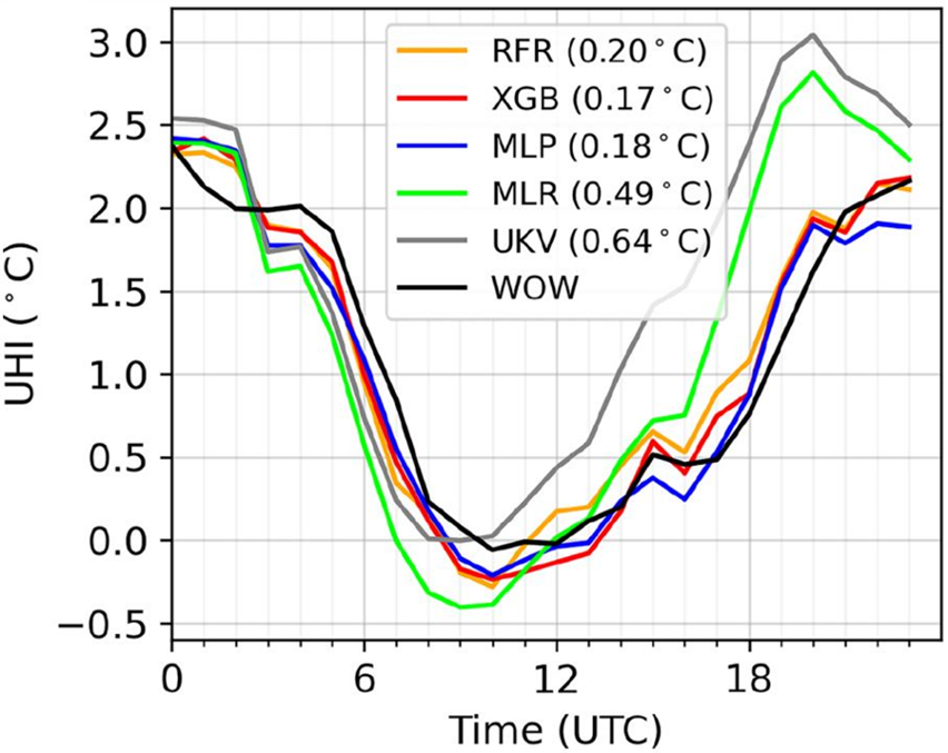
The machine learning corrections improve temperature prediction errors by up to 11% compared to the uncorrected weather forecast data. They can also improve the diurnal evolution and spatial distribution of the urban heat island contrast between rural and urban areas (Figure 2). A simple multiple linear regression model has been shown to perform almost as well as the machine learning methods for reducing temperature errors but cannot match the improved representation of the urban heat island.
This study provides an exciting template for ongoing research. This includes enhancing the information from operational weather forecasts across all areas of the UK from km-scale down to neighbourhood scales, via incorporating WOW observations across the UK and using the full observation record available. Indeed, it even seems likely that further improvements to temperature prediction over London will be enabled by use of more data within the machine learning training from outside the study region and time periods of interest. The value of other predictors beyond land use type, for example linked to building characteristics, can also be assessed.
Further development will depend on understanding how these methods can be incorporated alongside the Met Office’s IMPROVER probabilistic postprocessing system. The use of citizen weather station data offers significant benefits, but also requires careful quality control of input data to machine learning algorithms. The Met Office also continues to explore opportunities to further enhance observations over urban areas given the density of potential information and the very local scales on which conditions change. Research on city forecasts and future machine learning applications is underpinned by development of foundation urban-scale models that are capable of simulating neighbourhood-scale processes and interactions directly.