

A look back on January 2025's provisional weather and climate statistics.
January 2025 was the fifth sunniest on record for the UK, though temperatures were subdued compared to average, according to provisional Met Office statistics.
The month had a typical mix of UK winter weather conditions, with rain, snow and a named storm, but also some clear, crisp winter sunshine, especially for those in the north.
Sun shines for many
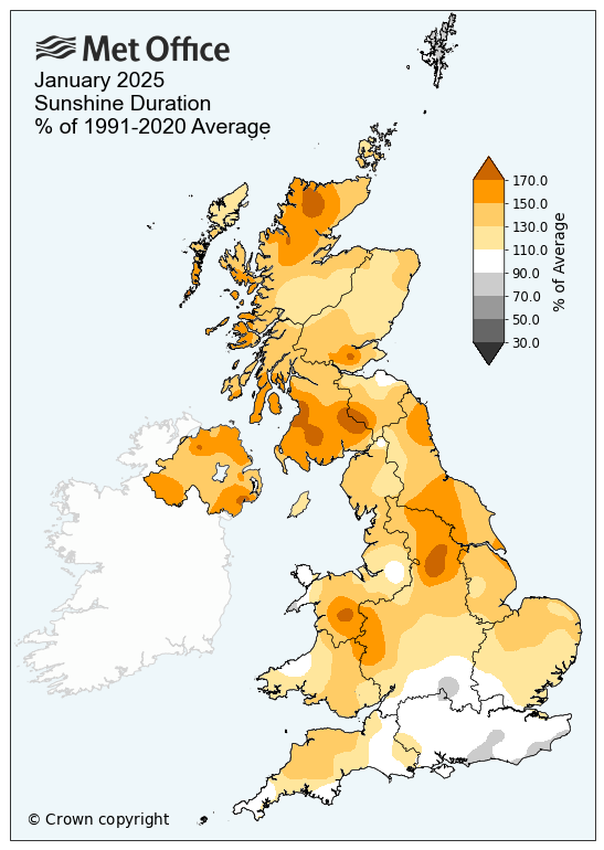
With an average of 61.8 hours of sunshine in January 2025, the UK saw 30% more sunshine than the long-term average for the month. This was enough to put it as the fifth sunniest January on record in a series which dates back to 1910. Interestingly, four of the five sunniest Januarys have occurred in the 21st century.
Those in the north led the way in terms of sunshine, though all UK nations saw more sunshine than their respective long-term average. Scotland had its sunniest January since 2001 with 49.4 sunshine hours. This is provisionally its fourth sunniest on record, with 1959 still Scotland’s sunniest January.
Met Office Scientist Emily Carlisle said: “While many will remember the impactful wet and windy weather from Storm Éowyn, it’s a mark of how unusually bright other days were that January 2025 will go down as one of the sunniest on record for the UK.
“We chiefly saw this as a result of frequent high pressure over the UK, bringing clear skies for many but also below average temperatures with little cloud to trap any warmth near the surface.”
Northern Ireland had its seventh sunniest January on record with 63.3 hours, while Wales had its tenth sunniest with 61.6 hours.
Colder than average January in the sunshine
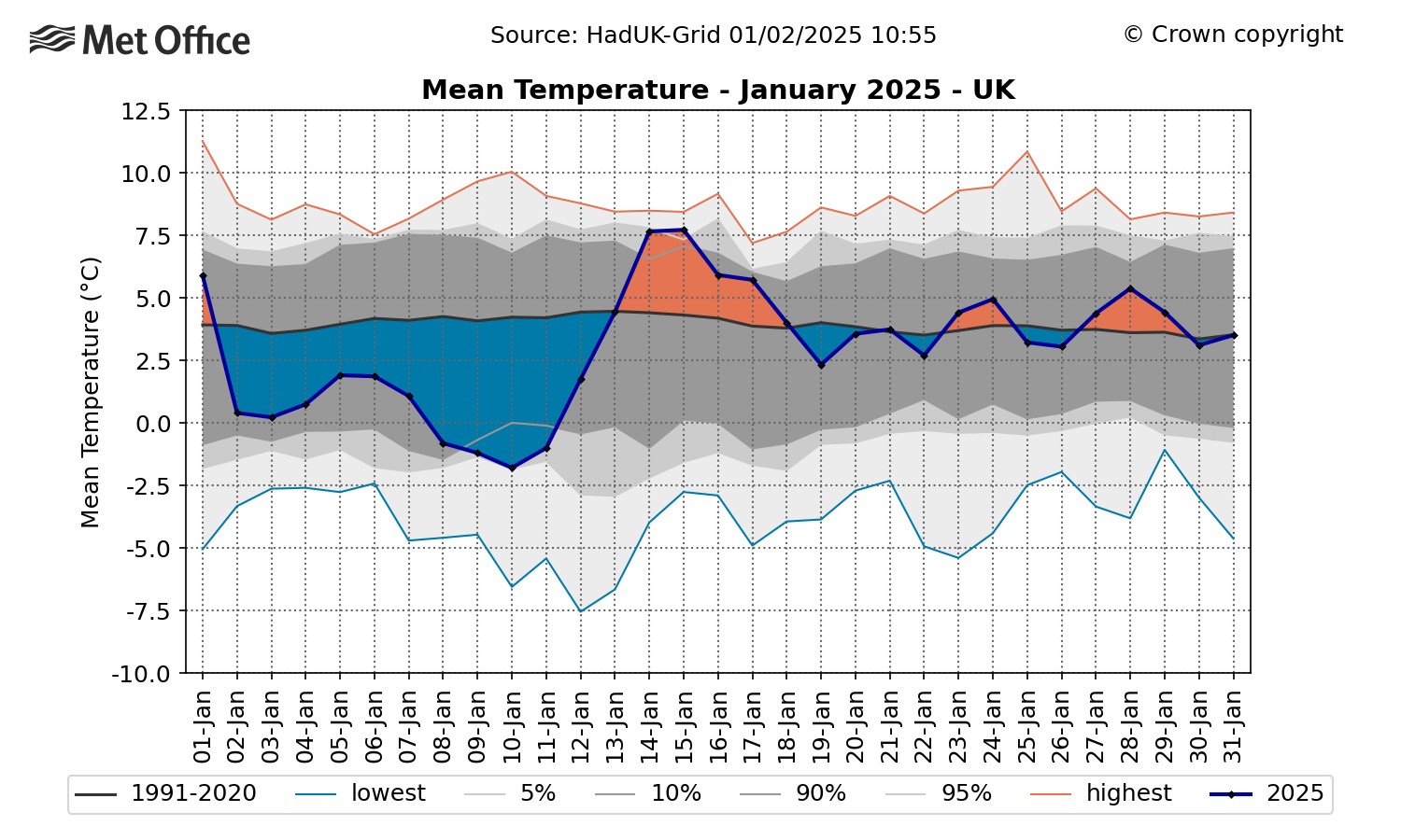
Thanks largely to an early month cold period, the UK’s January average mean temperature was 3°C, which is 0.9°C lower than the current long-term average.
The map below shows UK daily temperatures in the month compared to the long term average.
Meteorological averages work from the most recent 30-year averaging period, so it’s interesting to note that while an average January mean temperature of 3°C is colder than average by today’s standards (using a 1991-2020 averaging period), it would have been considered as average when compared to the 1961-1990 averaging period.
The 1961-1990 January long-term average mean temperature was 3°C, while the 1991-2020 long-term average is 3.9°C.
This upwards shift in the long-term average temperature is consistent with global patterns as a result of human-induced climate change.
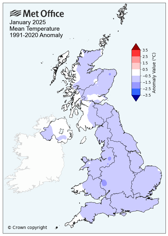
All UK nations reported mean temperatures in January 2025 below their respective long-term averages, though not enough to trouble any records.
The lowest individual temperature recorded in January 2025 was -18.9°C at Altnaharra on 11 January. This is the lowest UK temperature in the observational network since February 2021.
Wet in the south, but drier elsewhere
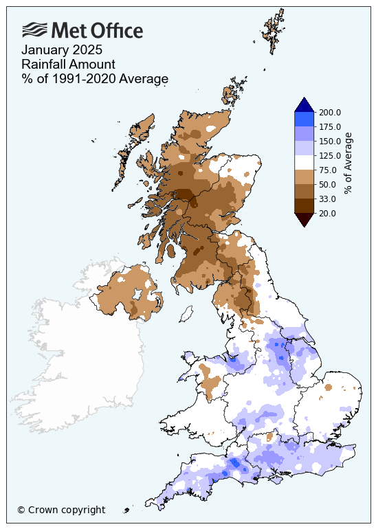
Rainfall amounts across the UK varied significantly in the month, with those in the south of England seeing 25% more rain than average, while those further north saw significantly less than average.
Scotland’s relative dryness (just 51% of its average for the month) helped to make the UK’s figures below average for the month, despite the rain further south. The UK saw an average of 95.8mm of rain, which is 79% of its long-term average for January.
Storm Éowyn
Storm Éowyn was the UK’s most powerful windstorm for over a decade, with red warnings, severe impacts and, tragically, fatalities.
A 100mph gust was recorded at Drumalbinand 15 UK stations with more than ten years of history recorded their own respective highest January gust.
While the depth of the low pressure isn’t the only indicator of storm strength, the lowest pressure recorded for Storm Éowyn was 941.9hPa on the Isle of Tiree, which was the lowest value since storm naming was introduced in 2015 and the lowest depth of pressure in the UK since 24 December 2013.
|
Provisional January 2025 stats |
Mean temp (°C) |
Rainfall (mm/%) |
Sunshine (hours/ %) |
|||
|
Actual |
91/20 anom |
Actual |
91/20 anom |
Actual |
91/20 anom |
|
|
UK |
3.0 | -0.9 | 95.8 | 79 | 61.8 | 130 |
|
England |
3.3 | -1.1 | 93.0 | 112 | 69.0 | 125 |
|
Wales |
3.5 | 0.9 | 146.8 | 95 | 61.6 | 130 |
|
Scotland |
2.3 | -0.6 | 90.3 | 51 | 49.4 | 140 |
|
Northern Ireland |
4.0 | -0.5 | 75.5 | 66 | 63.3 | 148 |