On 22 November 2024, we mark a significant milestone in aviation meteorology – the 40th anniversary of the Met Office's role as one of only two World Area Forecast Centres (WAFCs) globally.
For four decades, we've been providing critical global forecasts to enhance aviation safety and efficiency worldwide.
World Area Forecast Centres (WAFCs) are specialised meteorological centres with one operated by the Met Office and the other by NOAA (National Oceanic and Atmospheric Administration) in the USA. These centres work in tandem to ensure continuous, worldwide coverage of meteorological data essential for pilot briefings, flight planning, flight efficiency and overall aviation safety.
A history of innovation
In 1982, the International Civil Aviation Organization (ICAO) decided to establish the World Area Forecast System (WAFS) to provide global meteorological data that could be used for flight planning and hazard awareness. The first data sets comprised of wind and temperature data for ten different flight levels, four forecast timesteps, and hand drawn significant weather (SIGWX) charts valid for twenty-four hours in the future. Up until that point only regional area forecast centres existed, with very limited ability to take advantage of new technology and numerical models. Existing telecom networks could not distribute the WAFS data volumes, and a satellite broadcast was needed.
The Met Office was recognised for its unique capabilities, alongside our counterparts at NOAA in the USA, to produce the required global data sets for wind, temperature and significant weather and to disseminate the information via satellite.
We established satellite broadcast capability, with the Satellite Distribution System for Information Relating to Air Navigation (SADIS) in the UK, with a twin provision provided by the US. SADIS enabled us to broadcast crucial meteorological data across Europe, Africa, the Middle East, and parts of Asia. This system predated the internet era, showcasing the Met Office's pioneering spirit to keep evolving in leveraging technology for global benefit.
22 November 1984 was a pivotal moment, when the World Area Forecast System regulations first came into force in ICAO documentation. This milestone officially designated us as WAFC London and NOAA as WAFC Washington.
In the 1990’s the WAFCs and their WAFS were mature enough that the regional area forecast centres were closed.
Evolving technology
Over the years, our services have continuously evolved to meet the changing needs of the aviation industry:
- 1990s: We developed digital formats for significant weather charts (SIGWX) charts, enhancing the precision and usability of our forecasts.
- 2000s: We retired older gridded data and chart formats and introduced medium-level SIGWX charts that cover the height range Flight Level 100 to Flight Level 450 (10,000 to 45,000 feet), adapting to industry requirements.
- 2010s: The launch of Secure SADIS FTP (File Transfer Protocol) allowed us to upgrade model data resolution and introduce new datasets for icing, turbulence, and cumulonimbus clouds (CB). Our forecast timesteps also increased to cover the forecast period between six and thirty-six hours ahead at 3-hourly intervals (T+6 to T+36) and three new flight levels were added.
- 2020s: We've further refined our services, introducing higher resolution data and improved algorithms for turbulence and icing forecasts.
Looking to the future
Earlier this year we introduced SADIS API (Application Programming Interface), providing even higher resolution WAFS datasets, with some parameters having as many as fifty-six forecast levels. We expanded our forecasting ranges to provide hourly forecasts between six and twenty-four, and to provide forecasts that extend all the way out to one hundred and twenty hours, or five days, ahead.
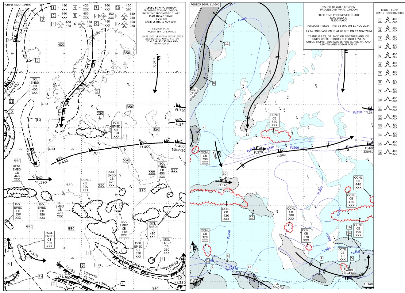
In early 2025, we'll be automating certain chart productions and offering multi-timestep SIGWX provisions further enhancing our service to the aviation industry. This means that instead of a single forecast for 24 hours in the future we will provide SIGWX forecasts that stretch from 6-hours to 48-hours at 3-hourly intervals. These new and improved data sets will contribute towards limiting the environmental impact of air travel, cope with increased traffic and capacity demands and help air traffic management strategies to mitigate against and avoid hazardous weather conditions.

(On the left: current significant weather charts (SIGWX) and on the right the new SIGWX that will start in January 2025)
A collaborative achievement
Our WAFC services play a crucial role in the daily operations of commercial airlines worldwide. By providing accurate and timely forecasts, we enable flights to be optimised for fuel efficiency and CO2 emissions reduction while providing relevant data to anticipate and avoid hazardous weather conditions.
We work closely with our counterpart, WAFC Washington operated by NOAA in the USA, to ensure continuous, seamless worldwide coverage. This collaborative approach guarantees that global aviation can rely on our essential meteorological services, even in the unlikely event that one centre becomes temporarily unavailable.
"We are proud of our partnership with the Met Office over the last 40 years and the advancements the WAFCs have brought and will continue to bring to aviation weather forecasting across the globe for decades to come.” - Debra Blondin, Deputy Director Aviation Weather Center / NOAA.
This 40-year success story is a testament to the dedication and expertise of countless individuals at the Met Office and our partner organisations, making air travel safer and more efficient for millions of passengers globally.
As we look to the future, the Met Office remains committed to driving modernisation and sustainability in aviation meteorology. Through our pioneering science and trusted services, we continue to shape the sustainable long-term future of the aviation sector.


