Despite the first named storm of the year, October has been a fairly typical month for UK weather.
October has been a rather typical month for UK weather, with provisional statistics showing rainfall and sunshine just below average and temperatures just above the long term 30 year average (1991-2020).
The month started with wet weather across the Midlands and East Anglia, followed by a brief interlude of settled conditions as high-pressure dominated. An Atlantic low-pressure system brought rain to the UK on the 6 October, especially in southern England.
A return to clear and settled weather on the 10 and 11 October provided good conditions for viewing the Aurora after another solar geomagnetic storm, before slow-moving weather fronts moved in and brought widespread rain to England and Wales.
On the 20 October, the first named storm of the season, Storm Ashley, arrived and brought heavy rain and strong winds to Northern Ireland, Scotland, and northern parts of England and Wales. Further frontal systems brought heavy rain to Scotland and Cumbria on the 27 October, before high pressure and cloud closed out the month.
Temperatures
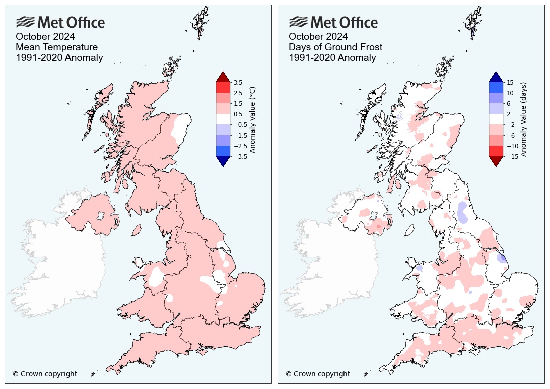
After a mostly cool first half of the month, temperatures increased from around 15 October to bring the average for the month (10.4°C) 0.7°C above the 1991-2020 average. All nations of the UK were consistently warmer than average ranging from 0.6°C in Wales to 0.9°C in Northern Ireland. Not one county across the UK was below average for mean October temperature.
Mild overnight temperatures caused a below average number of ground frosts across nearly the whole of the UK, especially in southern England.
 Rainfall
Rainfall distribution through the month has been much more varied across the UK, with much of Scotland, Northern Ireland and large parts of Wales having below average rainfall. Most of England was around average for monthly rainfall, though pockets of higher totals were seen in parts of the south, West Midlands and far northeast. Overall the UK saw 84% (103.5mm) of the long term average, with England just above average (101%, 91.3mm) and Wales (80%, 126.3mm), Scotland (72%, 121.5mm) and Northern Ireland (71%, 81.2mm) all below average.

Sunshine
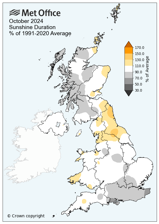
As with rainfall there was some regional variation in the sunshine hours compared to average for October. While Northern Ireland and Wales October sunshine hours were average, Scotland saw less sunshine in the west than in the east compared to average and England saw more sunshine in the north than the south compared to average. Overall, the UK saw 97% (89.4 hours) of the average monthly sunshine hours.

Notable weather
Storm Ashley, the first named storm of the 2024/25 season, brought wet and windy weather to the UK between 20-21 October with the strongest winds across north-western areas.
While crossing the Atlantic the area of low pressure interacted with a powerful jet stream as it approached the UK, rapidly intensifying and deepening as the central pressure dropped from 988hPa at 0600 19 October to 952hPa at 0600 20 October.
When it reached the UK it was a powerful, although not exceptional, Atlantic autumn storm. The storm brought travel disruption to the worst affected areas in the north and west. Ferry services in western Scotland and Northern Ireland were cancelled and dozens of flights cancelled at Belfast City Airport due to strong winds. In Scotland, some rail services were cancelled or had speed restrictions in place. Large waves battered exposed coastlines with beach material thrown up, and over 200 homes in north-east Scotland experienced loss of power.
The highest gusts were 82mph at Aberdaron, Gwynedd, 81mph at Killowen, County Down, 78mph at Tiree, Argyll and 76mph at Inverbervie (Kincardineshire). Wind gusts of over 100mph were recorded at a number of mountain top weather stations.
|
Provisional October 2024 stats |
Max temp (°C) |
Min temp (°C) |
Mean temp (°C) |
Rainfall (mm/%) |
Sunshine (hours/ %) |
|||||
|
Actual |
91/20 anom |
Actual |
91/20 anom |
Actual |
91/20 anom |
Actual |
91/20 anom |
Actual |
91/20 anom |
|
|
UK |
13.8 |
0.7 |
7.2 |
0.8 |
10.4 |
0.7 |
103.5 |
84 |
89.4 |
97 |
|
England |
14.8 |
0.7 |
7.8 |
0.7 |
11.3 |
0.7 |
91.3 |
101 |
99.8 |
97 |
|
Wales |
14.0 |
0.7 |
7.5 |
0.5 |
10.7 |
0.6 |
126.3 |
80 |
96.8 |
106 |
|
Scotland |
12.0 |
0.7 |
6.0 |
0.9 |
8.9 |
0.8 |
121.5 |
72 |
70.1 |
94 |
|
Northern Ireland |
13.6 |
0.7 |
7.4 |
1.1 |
10.5 |
0.9 |
81.2 |
71 |
87.4 |
102 |


