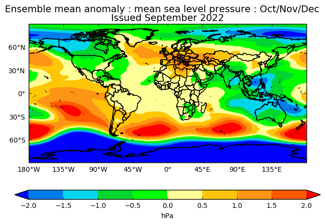
Professor Paul Davies Met Office Fellow (Meteorology) and Chief Meteorologist said; “Weather patterns for October look mobile with a westerly or south westerly air flow likely to bring Atlantic weather systems across the UK at times, resulting in periods of wet, and potentially windy weather, a greater proportion of which will affect the north and west. Temperatures are predicted to be above average in October.
“November and December look more settled with high pressure likely to dominate our weather. Exact weather conditions will be dictated by where the high pressure settles over the Atlantic and the UK, but we are likely to see a higher incidence of northerly airflows, preventing mild, moist air flowing to the UK from the Atlantic Ocean and increasing the potential for cold snaps with some threat of snow and ice, mainly in northern areas.

“The most likely scenario as we head into 2023 is for the risk of high-pressure to decrease, and a return to more unsettled conditions with wet, windy, and mild spells possible. However, there is still a risk we could see a Sudden Stratospheric Warming. If this happens it could potentially lead to a cold spell for the UK and northern Europe, although the chances of a very cold winter, comparable to 2009/10, are still low this winter.”
Professor Davies added; “It is important to bear-in-mind that long range outlooks are driven by global weather patterns and even if these influences, for example, suggest a higher-than-usual chance of a mild winter this would not rule out having cold spells, or even a cold winter. These scenarios would just be less likely based on the information available at the time the forecast is made. It is therefore also important to examine our regular monthly updates to the long-range outlook.
“Long range outlooks are unlike weather forecasts which cover the next few days. The science in this area is at the cutting edge of meteorology and the Met Office is one of the leading lights in this research area. Even with ‘perfect’ prediction systems and ‘perfect’ meteorological observations, the fundamental chaotic nature of the atmosphere will still limit the skill of these predictions.
“Although, the science, as yet does not allow for specific detail on, for example, the number of nights of frost, rain or snow over the coming months or when specifically severe weather may occur, long-range forecasts can provide useful information on the possible conditions averaged over the UK for a season as a whole. These predictions give an indication of how likely certain types of conditions, that may impact transport, energy, health etc., will be; allowing planners in these sectors to prepare accordingly. As we go through the winter months, we will obviously be able to give more detail of any potential winter hazards and will issue updated forecasts and warnings as and when needed.”
Winter Weather Drivers
One of the main influences on European winter weather is the North Atlantic Oscillation (NAO) – a positive phase corresponds to windy, mild and wet conditions, while a negative phase is related to still, cold and dry weather, which means we can obtain some indication of how likely a windy winter is. Another global factor that could influence the UK this winter is La Nina, a cooling of the ocean in the tropical Pacific. This promotes the development of high pressure in the Atlantic in late autumn and early winter which can lead to the potential for cold snaps for the UK. Conversely, sea-surface temperatures around the UK are above average for the time of year, meaning above average land temperatures are also possible.
You can check the latest weather forecast on our website, by following us on Twitter and Facebook, as well as on our mobile app which is available for iPhone from the App store and for Android from the Google Play store. Our long range outlooks are updated monthly. Keep track of current weather warnings on the weather warning page


