Warm this weekend, but colder weather is on the way
Author: Press Office
11:37 (UTC) on Fri 7 Mar 2025
Many places will enjoy a dry and very mild weekend, but a significant change in the weather is on the way, with much colder conditions from early next week.
Yesterday, Santon Downham in Suffolk reached 19°C, and similar high temperatures are expected again this afternoon as the UK is dominated by high pressure.
Cloud and outbreaks of rain will move gradually northwards this afternoon ☂️
— Met Office (@metoffice) March 7, 2025
The far north of Scotland though will see some bright or sunny spells, with the early spring warmth continuing across parts of eastern England 🌤️ pic.twitter.com/1IAgpOfe0t
Saturday will be another fine and dry day for most, with rain and wind in the north and some patchy rain in the southwest. Temperatures are still expected to be well above average, with 17-19°C possible fairly widely.
It’s another warm day on Sunday with sunshine for many, although a contrast in the far north of Scotland with persistent rain.
A change from Monday
As we welcome in the new week, we start to see a change in the very warm and dry conditions of late. A spell of rain will move south across the country on Monday, bringing a few wintry showers in the north/northeast. By Tuesday, we’ll start to see temperatures drop to below average across the UK. Rural spots in Scotland could see -4°C on Tuesday night, with a daytime maximum temperatures typically between 5-8°C.
Deputy Chief Meteorologist at the Met Office, Chris Bulmer explains: “A frontal zone will move south across the UK during Sunday night and Monday with much colder air following from the north. With these cold northeasterly winds, we are likely to see some wintry showers across the north and the east of the UK next week, but any accumulations of snow are likely to be largely restricted to hills. We’ll also see a return to overnight frosts in many areas.
“While there is uncertainty in the extent of rain and wintry showers through the middle of next week, there is higher confidence that below average temperatures will continue through the week, bringing a very different feel to the mild weather over the weekend. “
How far ahead can you predict snow?
Forecasting snow in the UK isn’t like some other places along the UK's latitude, where snow can be quite reliably forecast days or weeks in advance. Find out more about how far ahead snow can be forecast in the UK.
Are you WeatherReady for the cold?
Thinking ahead and preparing for what the weather may bring can make a real difference. There are some simple steps you can take to stay safe and healthy at this time of year – from preparing your home or business to taking care of yourself, your family and neighbours. Here are some tips from our WeatherReady partners.
Keeping your home warm this winter.
How the cold weather affects your health.
Looking after your pets in the colder weather.
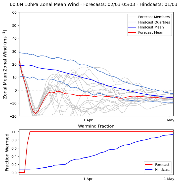
Are we expecting a Sudden Stratospheric Warning?
Over the last few days, the forecasts have become increasingly confident that we will see a sudden stratospheric warming (SSW) by mid-March. This phenomenon is characterised by a reversal of winds, the stratosphere polar vortex, high up in the stratosphere. These winds are currently weakening rapidly.
Professor Adam Scaife, Head of Long-Range Forecasting at the Met Office, said: “There is now over 80% chance of a SSW occurring by the middle of the month, this could lead to some impacts on weather in the UK toward the end of March. What those impacts might be will become clearer nearer the time.”
An SSW can result in a large area of blocking high pressure over northern Europe, and the UK, which can lead to a period of cold, dry weather. However, this is not always the case, and it's important to note that not all SSW events are followed by severe weather. More details on the intensity of surface weather effects from this event will be available in our weather forecasts.
Stratospheric polar vortex strength, 2 March - 5 March 2025