Temperatures rising into next week
Author: Press Office
12:30 (UTC+1) on Fri 26 Jul 2024
There’s a change in weather type as we go through the second part of the weekend, with temperatures set to increase.
Low pressure is still dominating at the moment, with showers in the north and west on Friday, and these could be heavy in some locations through the afternoon. It is a drier and brighter day compared to yesterday for most though, with sunny spells developing for many and feeling pleasant in the light winds. Tonight will feel cooler and fresher than of late.
A mix of sunny spells and showers this afternoon, with showers most frequent across the north
— Met Office (@metoffice) July 26, 2024
Some southern areas remaining largely dry and in the sunshine feeling pleasant pic.twitter.com/PPGwdOITJc
Saturday will be a day of sunny spells and showers. The showers will be heaviest in parts of Scotland, northern England, Wales and the Midlands, with the possibility of some isolated thunder. There will be fewer showers in the south and southeast, although these areas may still experience some lighter showers during the afternoon. Temperatures will be close to average, but again feeling warm in the sunshine.
Sunday looks to be the best day of the weekend, with a fine and dry day for many.
David Hayter is a Deputy Chief Meteorologist at the Met Office and said: “As we go through the weekend, the jet stream will weaken to the west of the UK generating an area of high pressure that will slowly move in across the UK. High pressure means the air is sinking from higher in the atmosphere and that brings drier, settled and sunnier weather.
“Temperatures will rise too, becoming widely above average. We could see maxima of 27°C in the south and 25°C in the northeast by Sunday. There’s a bit more in the way of patchy cloud in Northern Ireland, south and west Scotland and the northern isles, so temperatures will be lower there.”
As temperatures rise, you can keep up to date with the Met Office’s Pollen Forecast. Our forecasts also give UV level details and more information can be found here.
Further ahead
Conditions look to turn increasingly warm, or even hot, in central, southern and eastern areas early next week and it is possible some places may reach heatwave criteria. It’s uncertain how long this warmer weather will last though, with a possible breakdown from mid-week.
What is the heatwave criteria?
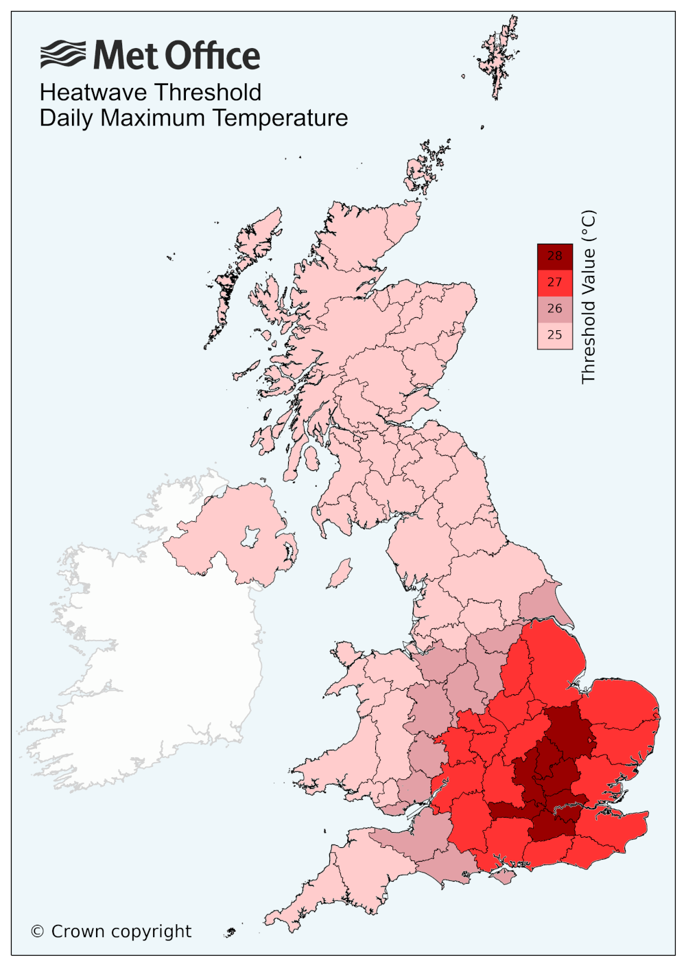
A UK heatwave threshold is met when a location records a period of at least three consecutive days with daily maximum temperatures meeting or exceeding the heatwave temperature threshold. The threshold varies by UK county, as shown in the UK temperature threshold map below.
You can find the latest forecast on our website, on YouTube by following us, on Twitter and Facebook, as well as on our mobile app which is available for iPhone from the App store and for Android from the Google Play store.