New warnings issued ahead of unsettled period of weather
Author: Press Office
12:02 (UTC) on Wed 4 Dec 2024
The UK will be affected by a series of low-pressure systems through the second half of the week and into the weekend, bringing very wet and windy weather for some.
The first of these low-pressure systems begins this evening (Wednesday), bringing rain and strengthening winds across parts of the west. A Yellow National Severe Weather Warning for wind in parts of north and northwest Scotland is currently in place.
⚠️ Yellow weather warning issued ⚠️
— Met Office (@metoffice) December 3, 2024
Strong winds across north and northwest Scotland
Wednesday 1600 – Thursday 0900
Latest info 👉 https://t.co/QwDLMfRBfs
Stay #WeatherAware⚠️ pic.twitter.com/O4N3KLP8Jj
Neil Armstrong is a Chief Meteorologist at the Met Office and said: “A spell of strong winds will affect parts of northern Scotland from Wednesday afternoon until Thursday morning. Winds will initially be south or southeasterly, but turn westerly during Thursday morning. Gusts will reach 50-60 mph widely with 65-75mph possible in places, especially around exposed coasts.
“A band of rain will also move eastwards across the UK overnight, bringing heavy rain to most parts of the UK as it crosses the country. We expect this rain to clear the southeast of England by 7am on Thursday morning, before another spell of wet and windy weather begins.”
Thursday will remain blustery, especially in the north, with further areas of rain, which will be heavy at times, moving eastwards through the day. Some of this rain will fall as snow over the highest ground in Scotland. Squally conditions are possible alongside the heavy rain in the south of the UK through the evening rush hour, bringing some potential challenges for the transport network.
A Yellow National Severe Weather Warning for wind across Northern Ireland, parts of Scotland, north Wales, northern England, the north Midlands and East Anglia has been issued from Thursday afternoon until Friday morning.
⚠️ Yellow weather warning issued ⚠️
— Met Office (@metoffice) December 4, 2024
Wind across Northern Ireland, western Scotland, and parts of north Wales north and east England
Thursday 1500 - Friday 0600
Latest info 👉 https://t.co/QwDLMfRBfs
Stay #WeatherAware⚠️ pic.twitter.com/9OBGged967
After the rain clears through Thursday evening, Friday will bring a short spell of calmer weather with a good deal of sunshine for many before another area of low pressure moves into western parts of the UK on Friday afternoon, with increasing cloud, strengthening winds and heavy rain moving in from the west.
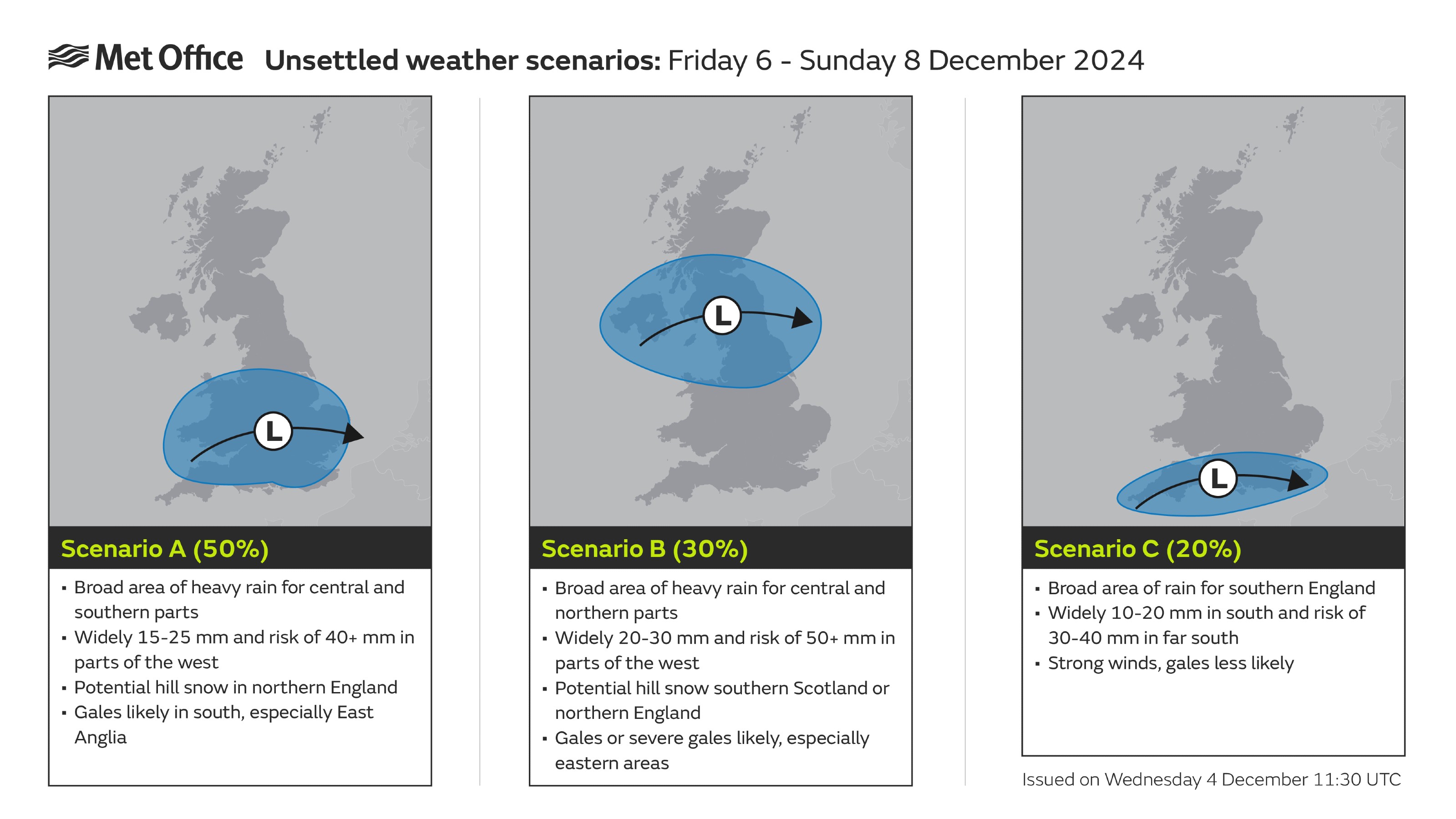
Mike Silverstone is a Deputy Chief Meteorologist at the Met Office and said: “While there is still uncertainty about the track and depth of the low pressure, Friday night and Saturday will be wet and very windy across parts of the UK.
“Some model solutions have the low pressure further north and much deeper, bringing very strong winds and heavy rain, whilst other model solutions have the low pressure further south and not as deep, still bringing unsettled weather but not as impactful."

Mike continued: “A Yellow National Severe Weather Warning for wind and rain has been issued for the whole of Wales and England from Friday afternoon to Sunday morning. The highest accumulations of rain may occur in northern Wales and northern England, where up to 50-70mm of rain may fall. More widely 15-25mm of rain is possible across the warning area. Gusts of up to 80mph are possible around western coasts, with 40-60mph gusts more widely across the warning area. Some further hill snow is possible in the north above 200m.
“Given the potential for disruption from this system, it is important to keep up to date with the latest forecast. National Severe Weather Warnings are likely to be updated as certainty around the unsettled weather increases.”
⚠️ Yellow weather warning issued ⚠️
— Met Office (@metoffice) December 4, 2024
Rain & Wind across England and Wales
Friday 1500 – Sunday 0600
Latest info 👉 https://t.co/QwDLMfRBfs
Stay #WeatherAware⚠️ pic.twitter.com/eUX4bybIS5
Once this low-pressure system has cleared the country, it looks likely that colder northerly air will again push down across the UK from the north.
You can find the latest forecast on our website, on YouTube, by following us on X and Facebook, as well as on our mobile app which is available for iPhone from the App store and for Android from the Google Play store.


