
Met Office launches new Local Authority Climate Service
Author: Press Office
11:15 (UTC+1) on Wed 9 Oct 2024
New service provides Local Authorities crucial information on climate change in their area.
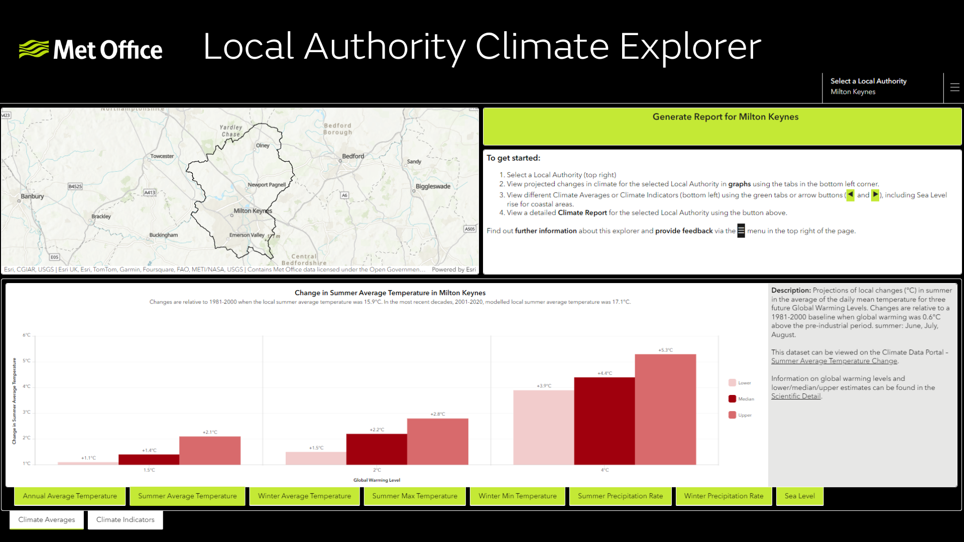
The Met Office has today launched the Local Authority Climate Service, a tool that provides local authorities with easy access to tailored information on climate change, to support local climate change adaptation planning.
It is clear that our climate is changing; underlying the natural variability we have in our weather across the UK is a continuing and increasing influence of human induced climate change which is shaping the weather we experience. Most notably we’re seeing more extreme heat and intense rainfall events, with impacts felt at the local level.
To deal with this, local authorities are considering their resilience to our changing climate and how they need to adapt to the weather we experience. The Met Office has worked with Esri UK to build the new operational service to help local authorities visualise climate challenges, explore climate projections and communicate a climate story specific to their local areas.
Head of Climate Services at the Met Office, Professor Jason Lowe OBE, said: “Local authorities are key in building resilience to climate change in our communities across the UK. It is vital that our climate projections are available in a format that makes them most accessible and useful for local authorities to apply in assessing risks and starting to plan how to best adapt to our changing climate.
“By working with Esri UK we’ve embedded our data into a range of industry leading tools to ensure tailored climate information can be used by the people who need it, and with suitable guidance to help them apply it. We know our climate is changing so it’s important we adapt to the extremes we’re likely to see more of. This new tool is a step forward in assisting local authorities minimise the impacts of climate change for the communities they serve.”
National Adaptation Programme
The service will equip local authorities with critical climate information helping them to make informed adaptation plans and decisions, empowering organisations to increase their resilience and meet statutory requirements. The Local Authority Climate Service is funded by Defra following a commitment in the third National Adaptation Programme, the government’s plan to adapt the UK to climate change which aims to reduce the costs from climate change impacts and make our economy and society more resilient.
Climate Adaptation Minister Emma Hardy said: “Tackling climate change not only means accelerating progress towards net zero, but also strengthening the resilience of our communities and adapting to the demands of a changing climate.
“Local communities are already being impacted by more frequent and extreme weather, as well as overheating and droughts. These effects will vary in different parts of the country and this new service will support local authorities to more effectively plan and respond.”
Geospatial integration
The Local Authority Climate Service is a new tool built using Esri functionality to enable Met Office Climate Data to be viewed geospatially. It features functionality which enables data to be viewed and analysed on a map and use ArcGIS online to overlay climate data with other open data or data specific to the user.
Managing Director of Esri UK, Pete Wilkinson, said: “The Local Authority Climate Service is another significant milestone in our partnership with the Met Office. GIS is the natural delivery mechanism to place authoritative climate data in the hands of those that need it most, supporting better adaption planning at a local level. Geospatial software makes this critical data easier to use, opening it up to a much broader audience, which significantly extends its value and benefits.”
The Local Authority Climate Service has been developed with input from future users to ensure it provides the tools and data required.
Cllr Shanika Mahendran, Cabinet Member for Sustainability at Milton Keynes City Council said: “Testing the new Local Authority Climate Service tool from the Met Office has provided Milton Keynes with a stronger evidence base to prepare the council’s services against future climate impacts. We are looking forward to continuing exploring and implementing this resource across all services.”
The service is now fully available for use, and as we learn more about user requirements, we are inviting feedback to help drive further improvements. 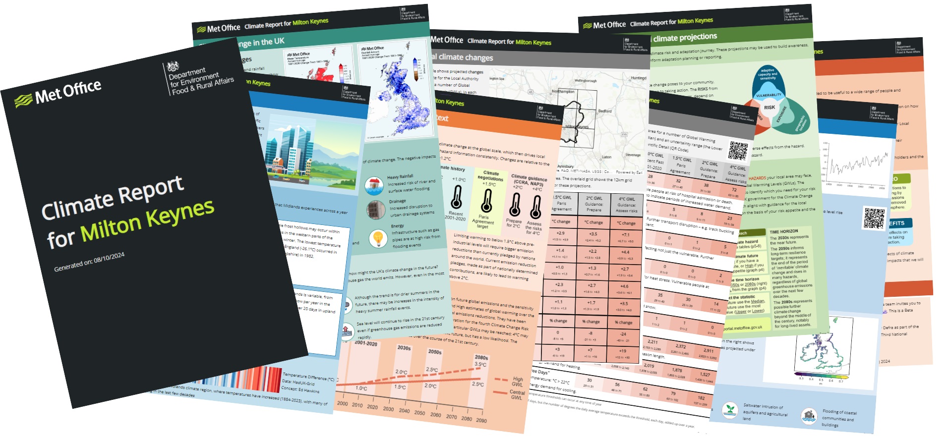
Climate data portal
The new service builds on the Met Office Climate Data Portal. The free tool makes it easier for businesses or government organisations to combine open climate data with their own data and reveal the future impact of extreme conditions on their operations, including heatwaves, floods or droughts. The project is part of a strategic partnership between the Met Office and Esri UK who have been working together for over 20 years.
The Climate Data Portal is supported as part of the Hadley Centre Climate Programme (HCCP) and is, in part, funded by DSIT (Department for Science Innovation and Technology) and supports the work of DESNZ (Department for Energy Security and Net Zero) and other UK Government departments.