Brief respite before further winds and rain later in the weekend
Author: Press Office
11:29 (UTC+1) on Fri 27 Sep 2024
A briefly drier interlude of weather will develop for many on Friday and Saturday, but further wind and rain will reach the UK on Sunday and into Monday.
Southern and central parts of England have had a very wet period of weather in the last few days, with recent Amber weather warnings preceding flooding and travel disruption for some.
Some counties in southern and central England have already had more than 250% of their average September rainfall, with the month’s full provisional statistics to be released on 1 October.
Friday and Saturday will see generally drier weather develop for much of the UK, though this will coincide with a drop in temperatures as a northerly airflow develops and could introduce widespread frost on Friday night.
Exceptions to the drier conditions will be some showers in northern and eastern coasts, with these sporadically drifting further in land at times.
Wind and rain to come
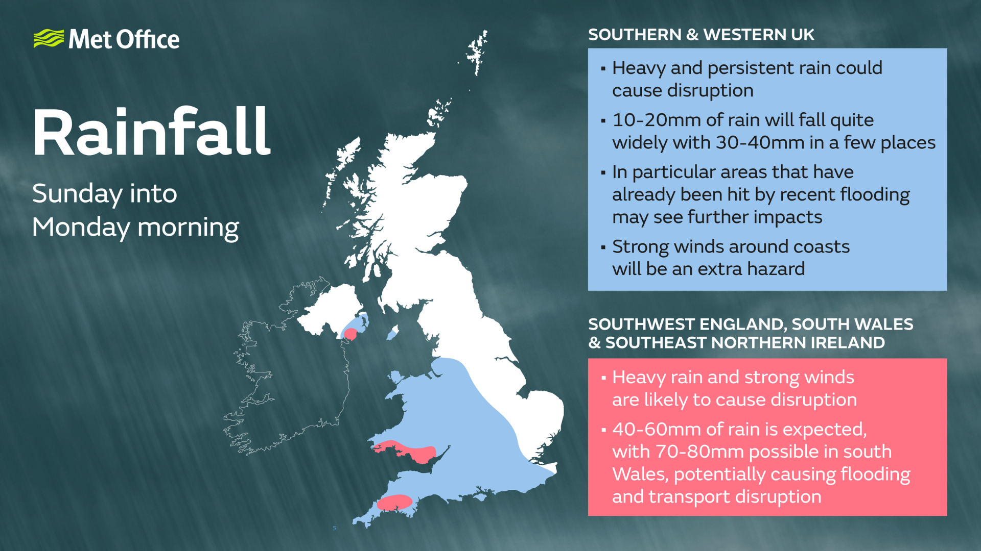
While Sunday will start dry and fine for many, further wind and rain will move in from the southwest, with a Yellow warning for wind issued for southwest England and parts of Wales.
⚠️ Yellow weather warning issued ⚠️
— Met Office (@metoffice) September 27, 2024
Strong winds across parts of Wales and southwest England
Sunday 0900 – 2359
Latest info 👉 https://t.co/QwDLMfRBfs
Stay #WeatherAware ⚠️ pic.twitter.com/hdKLj8CHli
Met Office Deputy Chief Meteorologist Dan Holley said: “After a drier interlude for many on Friday, Saturday and early Sunday, attention shifts to a deep area of low pressure to the southwest which will bring rain and strong winds to parts of the UK, potentially impactful for some.
“A Yellow warning for wind has been issued for much of Sunday across portions of southwest England and south and west Wales, where gusts could reach or even exceed 60 mph on exposed coasts, and 50-55 mph more widely. This system will gradually track eastwards through Sunday and into Monday and will bring another spell of wet weather fairly widely across the UK.
“We’re continuing to monitor the rainfall with this system, as rain falling on saturated ground in flood-hit areas has the potential to cause further impacts. Stay up to date with the latest forecast as further warnings could be issued in the coming days.”
Kate Marks, Flood Duty Manager at the Environment Agency, said: “Following heavy rainfall across the country overnight, there has been localised river and surface water flooding across central England, Yorkshire and the North East. Further, minor river flooding impacts are also possible in these areas today and into Saturday.
“Environment Agency teams continue to be out on the ground, supporting local authorities in responding to surface water flooding. We urge people to plan their journeys carefully, follow the advice of local emergency services on the roads and not to drive through flood water – it is often deeper than it looks and just 30cm of flowing water is enough to float your car.
“People should check their flood risk, sign up for free flood warnings and keep up to date with the latest situation as well as following @EnvAgency on X for the latest flood updates.”
Next week
After a rather wet Monday, and perhaps extending into Tuesday in some eastern and southeastern areas, it should become somewhat drier and brighter more widely around midweek. However, there are signals for the potential of further wet and windy weather towards the end of next week.
You can find the latest forecast on our website, on YouTube, by following us on X and Facebook, as well as on our mobile app which is available for iPhone from the App store and for Android from the Google Play store.