
A warm and settled week
Author: Press Office
12:26 (UTC+1) on Mon 24 Jun 2024
Temperatures will continue to rise this week, with a change to our weather expected on Thursday.
This morning patchy fog in the south will clear to leave a fine day with light winds and further warm spells of sunshine. Scotland and Northern Ireland will see cloudier conditions and some showery rain – perhaps even heavy showers and isolated thunderstorms for parts – on Tuesday afternoon. The highest temperatures are again expected in the southeast, where they could peak at 30°C in London. Elsewhere, temperatures widely looking at 25 to 28°C.
Some low cloud with mist and fog for western parts of the UK on Tuesday morning
— Met Office (@metoffice) June 24, 2024
Light rain and drizzle across Northern Ireland and western Scotland 🌧️
Elsewhere bright and sunny start as temperature climb through the morning 🌤️ pic.twitter.com/JBSOOE7y43
Wednesday looks to be the warmest day of the week for many with mid-to-high 20°Cs widely. Parts of the southeast could reach 31°C. However, it will be a cloudier start for many parts of the north/northeast with some light rain or drizzle in places helping to subdue temperatures there. Through the afternoon, some extremely isolated heavy showers are also possible across some western areas such as northern Wales and northwestern England.
Mark Sidaway is a Deputy Chief Meteorologist at the Met Office and said: “Although we are expecting to see some very warm temperatures this week, it may not be the wall-to-wall sunshine and blue skies people are expecting as there is likely to be some cloud around in places.
“Some areas, mainly central and eastern England, will see temperatures which exceed the heatwave criteria. To be officially recognised as a ‘heatwave’ though, the temperature must be reached for three consecutive days.
“Although we are looking to enjoy some nice warm temperatures, the weather this week does not look particularly exceptional or extreme.”
The heatwave threshold varies by county, with geographical differences reflecting the differences in climate across the UK.
UV levels will be high through the week for most places in the hot sunshine 😎
— Met Office (@metoffice) June 24, 2024
Make sure you are protecting yourself if you are out and about pic.twitter.com/WXNNcFKZYM
Change in the weather from Thursday
A transition to fresher conditions is looking likely through Thursday, with a cold front bringing a band of cloud and showery rain running east/southeast across the country.
It will still feel very warm ahead of this, with the southeast hanging on to the warmth and sunshine. There is also a chance of isolated heavy showers and thunderstorms developing during the afternoon.
By Friday, fresher conditions are likely to be established across all areas, with temperatures near or a little below average in the northwest, and near or a little above average in the southeast. There will also be plenty of dry weather with sunny spells, although showers and breezy conditions most likely in the north/northwest.
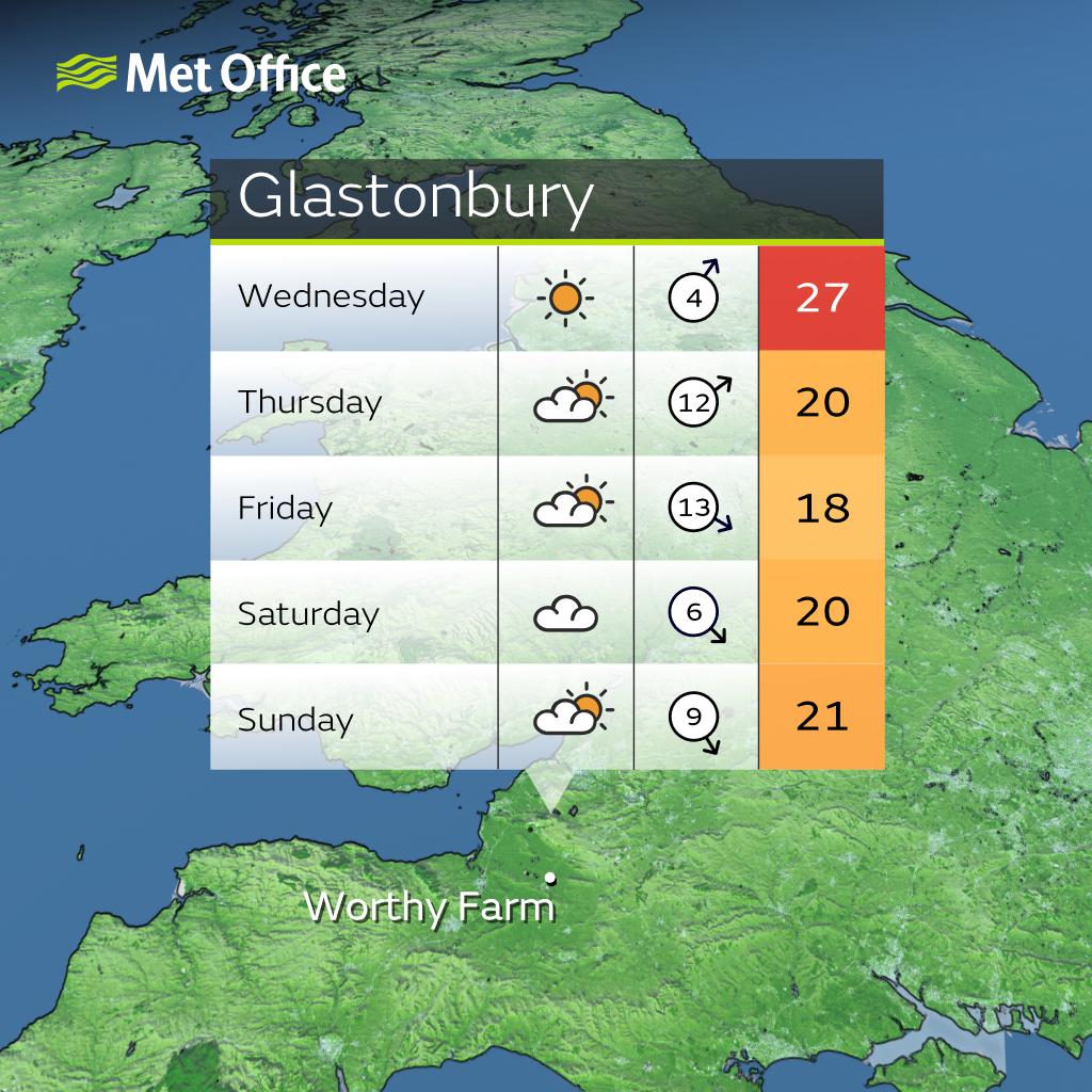
Glastonbury Festival outlook
With lots of attention on Somerset as Glastonbury kicks off, the weather is likely to be mostly warm, dry and settled. On Wednesday we’re likely to see hotter temperatures of 25°C to 27°C in Somerset as the sunny weather continues and although it’s not impossible a heavy shower could develop, it’s more likely to remain dry.
On Thursday as the cold front progresses south-eastwards, it will bring cloudier and slightly breezier conditions through the day and possibly some light rain in the afternoon.
Friday through to Sunday are forecast to be mostly dry, although largely cloudy, and there is still some uncertainty with showers remaining possible. Temperatures throughout this period are to be around or slightly above average, with approximate maximum temperatures of 18°C to 21°C.
You can find the latest forecast on our website, on YouTube by following us, on Twitter and Facebook, as well as on our mobile app which is available for iPhone from the App store and for Android from the Google Play store.
Updated at 09:43 (UTC+1) on Tue 25 Jun 2024