Further wet and windy weather to come
Author: Press Office
16:53 (UTC+1) on Wed 20 Sep 2023
A typically autumnal mixture of sunshine and showers is likely in the coming days, with further wet and windy weather likely from late on Saturday into early next week.
After a number of weather warnings for rain and one for wind will lapse later today (Wednesday) and in the early hours of Thursday with sunny spells and showers likely ahead of the weekend.
Speaking in the Met Office’s 10 Day Trend, Presenter and Meteorologist Aidan McGivern said: “A band of rain will clear by the start of Thursday and that will be followed by sunny spells and showers with low pressure never too far away from the UK. Some cooler weather, along with some chilly nights, are likely as we move towards the weekend.”
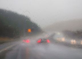
Andrew Hitchings, Flood Duty Manager at the Environment Agency, said: “A period of slow-moving heavy rain means surface water flooding is probable across parts of the Midlands and the North and possible more widely across much of England today, while river flooding is probable across parts of Cumbria and possible more widely. Surface water flooding is also probable and river flooding possible across parts of the East and South East of England from Wednesday afternoon overnight into early tomorrow morning.
“Environment Agency teams will be out on the ground, undertaking preparatory operational activity to minimise the impacts of flooding where possible. We urge people not to drive though flood water – it is often deeper than it looks and just 30cm of flowing water is enough to float your car.
“People should check their flood risk, sign up for free flood warnings and keep up to date with the latest situation at https://www.gov.uk/check-if-youre-at-risk-of-flooding or follow @EnvAgency on X, formerly known as Twitter, for the latest flood updates.”
Wet and windy weather to come
Aidan continued: “A ridge of high pressure will bring a fine start to the weekend. However, to the west of the UK we start to see the influence from what is currently Hurricane Nigel.
“As Nigel moves north over the Atlantic, it gets picked up by the jet stream and moves towards the west of the UK, whilst losing its tropical characteristics. The specifics may differ by the time we get to Sunday but computer models show this area of low pressure sitting to the west of the UK. The worst of the winds from this former hurricane aren’t expected to cross the UK, but various remnants of wind and rain swirling around that low pressure will bring a contrast to the more settled start to the weekend.”
More persistent, and at times heavy, rain is likely to influence the weather from the west by Saturday afternoon, with further rain likely on Sunday and Monday, which could bring some disruption for some through the weekend and into early next week.
“Some of this rain is likely to be quite slow moving on Sunday and Monday, with in excess of 100mm of rain possible over some of the hills as part of this event,” said Aidan.
Be prepared for weather warnings to change quickly: when a weather warning is issued, the Met Office recommends staying up to date with the weather in your area.
You can check the latest forecast on our website, by following us on Twitter and Facebook, as well as on our mobile app which is available for iPhone from the App store and for Android from the Google Play store. Keep track of current weather warnings on the weather warning page.